GPS Global Positioning System with maps of bike trails

marty

1 MW
Joined
Apr 19, 2007
Messages
2,812
Location
Buffalo, New York USA
Using Garmin nüvi 350 now. Set it for bicycle and it takes me on side roads. Little girl inside the box tells me when to turn. Even plays music. Johnny Cash for some unknown reason? Garmin nüvi 350 is good. Got perfect gismo to mount it to handlebars from http://www.ram-mount.com

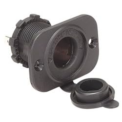
Now I am starting to think about GPS for Electric Bike Project # 2. Bought this Marine Grade Cigarette Lighter Socket to power GPS. Will get DC/DC converter to change 48V to 12V.
31BRN43V71L._SL500_AA250_.jpg

Are there any GPS that have bike / walking trails? Garmin nüvi 350 has no knowledge of off the road bike trails.
 
If you run a DC-DC converter for 12V, and you don't already have lights running off your main battery...

12V DC supply is a great possibility for headlights and taillights.
 
Been through all kinds of bicycle lighting ideas.

48 Volt Lights for Electric Bicycle
http://endless-sphere.com/forums/viewtopic.php?f=2&t=2951
Too big. Will sell box of all kinds of 48V bulbs, front and rear lights, and ideas that will never happen, if anyone wants it?

5 Mode Tail 5 Red LED BIKE CYCLE BACK Safety Light-LA20
http://endless-sphere.com/forums/viewtopic.php?f=2&t=4184
Cheap crappy plastic, and too hard to figure out how to turn on with switch. This will make a fun toy for a 6 year old.

CREE LED XR-E P4 Bike Bicycle Light B200
http://endless-sphere.com/forums/viewtopic.php?f=3&t=3491
As of today. This will be the front lights. Ordered 4. Waiting for delivery.

As of today rear light will be Busch & Müller D'TOPLIGHT XS
This light is intended to run on 6V dynamo.
325al.jpg


Hope to run all lights on DC/DC converter with 5V output. And use this switch.
SWITCH_HBS01.jpg
 
marty said:
Are there any GPS that have bike / walking trails? Garmin nüvi 350 has no knowledge of off the road bike trails.

Not yet. The number 1 digital map provider is NavTeq (recently acquired by Noikia) and they are all about roads and vehicle traffic. I have to believe this is because it makes the most business sense. As the market for little personal navigational devices is becoming more and more saturated I hope to see some devices coming out with the biker and hiker in mind. The problem is the lack of availability of reliable trail/path data. The Garmin you have is probably the best thing going for this sort of thing at the moment.
 
What about a thread to collect GoogleEarth .kmz .kml files of your bike rides. People and upload the files to it. I believe Gramin will allow upload and download of these files, n'est-ce pas?
 
Back
Top