Dear Diary: Travel Log of an Ebiker

Kingfish

100 MW
Joined
Feb 3, 2010
Messages
4,064
Location
Redmond, WA-USA, Earth, Sol, Orion–Cygnus Arm, Mil
Saturday, May 4th.
Dear Dairy,

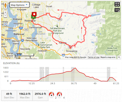
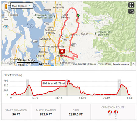
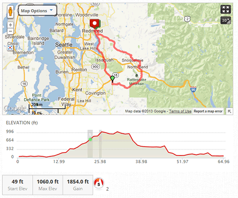
The weather has turned really nice the past couple of days and today it’s supposed to get to 70°F. Made up a couple of routes on mapmyride.com and I’m going to try to reach Rattlesnake Lake from the backside via Hobart; it’s about 65 mile loop. Wish me luck!

DD20130504-0.png

Planned route. Blocked about where the green marker is.

12:45 PM: Off to a late start; leaving now.
2 PM: Well here I yam stuck in Hobart. The weather is perfect for riding. Lots of traffic on the roads. But the problem is that Google/Mapmyrides.com show three connecting routes to Cider Falls Road (the back way into Rattlesnake Lake via Hobart) and they are all dead ends.
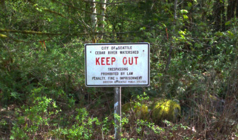
2:45 PM: Checked on last route and there’s a sign that says ABSOLUTELY NO TRESPASSING/VIOLATORS WILL BE PROSECUTED with a locked gate and barbed wire; no way to get passed that barrier even if I wanted. Homeland Security to the extreme. I don’t know this part of the realm very well, so I’ll just thread my way back somehow.
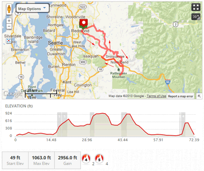
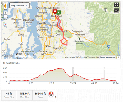
4 PM: Still on the road. Meandered back to Issaquah and took West Lake Samm (road) back towards Redmond. It’s getting late and last call at the Brewery’s BDay party is 8 PM; not much time to get cleaned up, walk to the brewery, and have a pint; I’ll just go direct and drink juice.

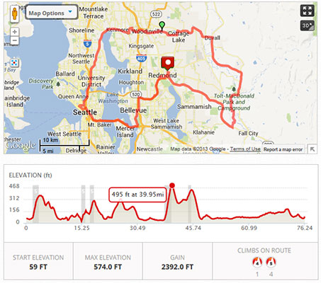
DD20130504-1.png

Ad hoc route. A venturesome way to get home.

6 PM: At the Brewery. Crowded, good band, lot's of pals I haven't seen in a while. One of them couldn’t stand to watch me drink water anymore so he offered to give my bike a lift home in the back of his truck. I ordered two pints.
7:30 PM: End of a great day. 58.4 miles. Conspiring to go out again tomorrow. :twisted:

Cheers! KF
 
Right on, traveling by e-bike is such a liberating concept in my mind. Especially if you can carry a charger with you.
 
Nice ride. Does that first route go past the falls? Lots of fun riding in your neck of the woods.

I have a brother in Port Orchard. With all my various visits to Seattle, I have probably spent somewhere close to a year out there. Actually, Seattle, Gig Harbor, Puyallup, and Port Orchard. Loved my time there, even with someone trying (and failing) to mug me at a bus stop.

Good riding all over the place. Good beer too!
 
I'm on another ride now. In North Bend having a burger at that cafe where they always at pie in Twin Peaks. Stopped at the Falls too. Once again my objective was blocked - no access to Tolt back country so I turned south to NB for lunch. Still above 60% on the pack after 28 hilly miles so I'm going to check out Rattlesnake Lake from the north and see if I can access Cedar Falls Rd from the north.

B-eautiful weather today! :)
From the Road, KF
 
Is it roads over dams that are blocking your routes? After 911, they blocked the two roads over dams in my area.

In one case, you can still drive right up to the base of the dam. Makes perfect security sense to me. :roll:

Wish I was riding long trips. Last week my fatigue kicked in extra hard. No doubt because I rode 12 miles a few times the previous week. Enjoy it while you can.
 
Sunday, May 5th.
Dear Diary,

I’m a little bit stiff from yesterday’s ride, but game to try it again cos it’s supposed to get up to 79°F. Put the charge on the bike at 8 AM and made new plans to reach the Tolt Watershed via the southern route (see pic).

DD20130505-11.png

Da Plan: CCW loop. Woz blocked at the "X".

10:30 AM: Charger finished. As with yesterday I am running with the Commuter Pack (30Ah) + Saddlebags (20Ah) for extra distance. Topped off at 63.3V (15S10P) – nearly ready. For breakfast, I made 3-egg scratch pancakes w/ real maple syrup + fresh ground Italian Roast coffee.
11:05 AM: Heading out. I didn’t use my camera yesterday and decided instead to save weight and remove it. Crackin’ day for a ride!

DD20130505-00.jpg

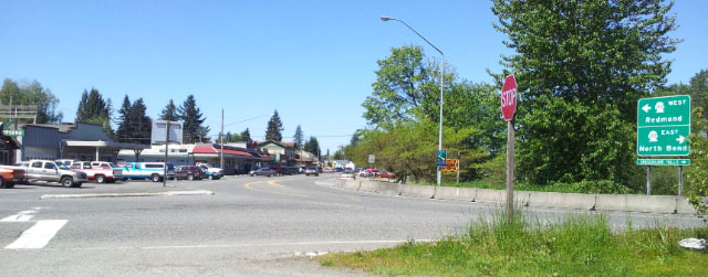
Fall City looking west. I came down that road in the center, and am going to the right. Preston is to the left.

11:45 AM: Stopped at Fall City for an 8-minute rest after 15 hard miles. Water-up.

DD20130505-01.jpg

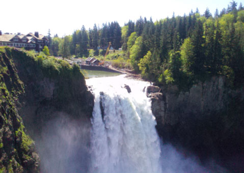
Snoqualmie Falls. Taller than Niagara. Good flow today. The hotel is the background is the same that was used in "Twin Peaks".

12:10 PM: Stopped to take a quick pic of Snoqualmie Falls, then onward onto Tokul Road which will take me to the Tolt Reservoir Road.
Time? Well this is a bust. Locked out again. Sign says “NO ATVS, MOTORCYCLES, MOTOR VEHICLES WITHOUT PERMIT. NO TRESPASSING.” This got me to thinking – it didn’t say “no bicycles, or no hiking”… but the “no trespassing”, well – that kinda bottom-lines it for all. Oh well – off to North Bend for lunch!

DD20130505-02.jpg

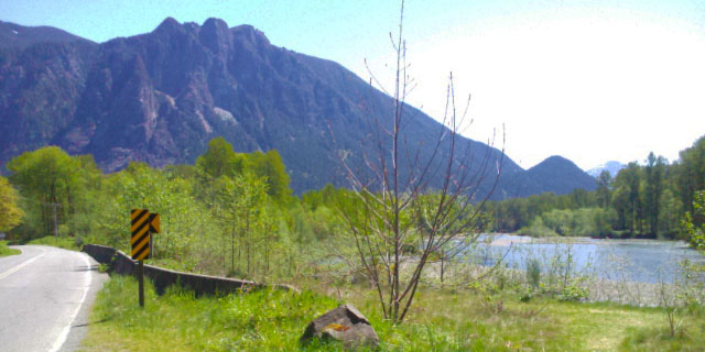
Mount Si (pronounced like "sigh"). Great hike to the tippy top. Apologies for my SmartPhone camera: It's crap.

DD20130505-03.jpg

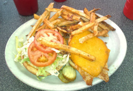
Lunch: Chicken & Cheese Burger with OJ. I only ate about 1/4 of the fries - however they are "bottomless" if you want more.

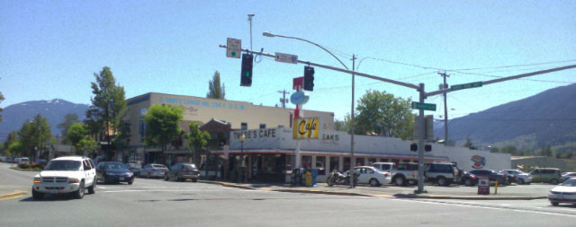
1 PM: I’m at Twede’s Café in North Bend for a Chicken & Cheese burger with orange juice. This is the same café where the characters in Twin Peaks ate pie. After 28 hilly miles, the pack still shows 59.5V – plenty for more reconnoitering. After lunch I took some pictures and talked to locals interested in my ebike.

DD20130505-04.jpg

Twede’s Café. Looking east more or less from the NW corner. The edge of Rattlesnake Mountain is on the right.

DD20130505-05.jpg

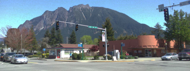
Mount Si, looking NE from the SW corner. It's a huge frippen mountain rising about 4000 feet from the base.

1:55 PM: Left North Bend for Rattlesnake Lake; going to check out where Cedar Falls Road goes from the north end.
2:11 PM: Rattlesnake Lake is packed with people! I espy a crowd sitting on top of Rattlesnake Mountain’s bluff; what a zoo. Kept going to the end of the road and it too is locked. Hmmm. Connectivity is spotty though I have an idea on a way home. At 35 miles and 58.7V – I turn back and head for the barn.

DD20130505-06.jpg

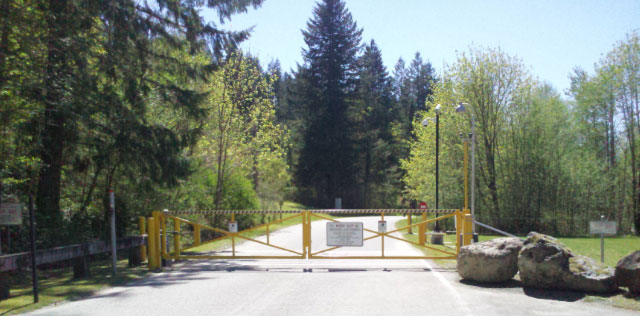
End of Cedar Falls Road from the north. This is the 3rd locked gate I've encountered over the weekend.

DD20130505-07.jpg

No mistaking it, NO means NO. Bummer.

DD20130505-08.jpg

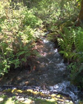
A babbly brook that looks a lot better than this crappy picture. Why do I do this to myself?

2:50 PM: In Preston; got to stop and catch my breath for a 5-minute breather and water-up. I don’t think I’ll do that again. On the way back down the slope from Rattlesnake Lake I blasted as fast as I could go – all tucked in. Then I jumped on I-90 for 11 miles and blasted on down to Preston. So much crap in the margins. Super loud on the freeway. Not a terribly hospitable route though it saved me a lot of time. I just need five minutes to shake off the nerves and water-up. This is my last rest stop. At 49 miles, I still have 57.5V – good enough for a tangent through Carnation.

DD20130505-09.jpg

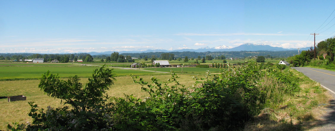
Wide panorama of Snoqualmie Valley looking SE from NE 60th Street with the tiny town of Carnation barely visible in the center, Mount Si on the left of the cut, and Rattlesnake Mountain on the right. Click here to see the entire view.

4:00 PM sharp: I yam home; what a rush! From Preston – went fast downhill to Fall City; hardly knew I wasn’t using throttle for a good portion. Didn’t stop at the bottom and continued onward to Carnation. Thought about stopping though the only decent spot with shade is on the south side coming into town… and I missed it. Plugged along and got off the highway for some backroad solitude – but no, that too was busy with all sorts of travelers. Drove past the Carnation Farms (famous for milk products; Nestlé once had a research facility here; maybe they still do). Drove past properties I once considered for purchase; can’t recognize them now. When I hit the bottom of Novelty Hill I still had 55.5V when under throttle – and the ebike displayed no lag whatsoever all the way to the top! Then it was a nice speed run down the other side into Redmond.

DD20130505-10.jpg

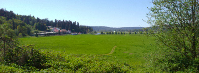
Carnation Farms, looking about north. Beautiful countryside. In winter this land can flood.

Problems:
  • There is something not right with the rear derailleur; it’s not shifting. Yesterday I had the bike mechanic inspect it and we thought it was just a cable that pulled out of the stop – though something else is going on. I’ll need to get that looked at before making another long trip.
  • Also, the turn indicators are once again are detaching from their mounts. I need to source a replacement.
  • The Bar-Ends we’re finally tested on this trip and they were much better than the Aerobars they replaced; excellent control – however the hand posture is not optimum although now I understand what to look for in a replacement. Marked low-priority.

DD20130505-12.png

The actual route, sort of a figure-8.

Final Stats: 73.4 miles, pack strong at 56.3V. Average Speed: 25 mph, Max Speed: 44.6 mph.

Got a shower and then later enjoyed pilsners with my mathematician pal. He got to calculating and said that the ebike expended 1260000 joules! I’ll need to double-check that figure. He then went on to say our bodies produce 60W just sitting here breathing. It doesn’t seem like it would make for a very good energy model for the Matrix Machines – but if you have billions of bodies then I guess it doesn’t matter. :wink:

Anyways – here’s to a good ride. That’s 131.8 miles over the weekend. Off to a good start.
Cheers, KF
 
June 22nd.
Dear Diary,

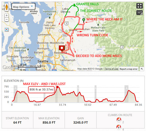
We’ve had two days of sunshine in a row. If we get a 3rd tomorrow – “summer” will be officially here in Seattle! I decided to try for Granite Falls again since my last attempt went out the window by colliding social agendas. Once again I employed the Saddlebags. Prepped the 2WD and I was out the door about 12:50 PM. Yes – I know that’s a terribly late start, but then this is the 2nd longest day of the year and the sun won’t set in these parts until 9 PM, so there’s plenty of light. The temps were approaching 68°F and were supposed to top out at about 70 (I learned after the fact that it was closer to 75° when I pulled back into town). Here’s how the day went:

12:50 PM: Departure with 15S10P (63V/50Ah). The first leg from Redmond to Monroe went well. However my memory had a disconnect in that town and for some reason I got onto the wrong path taking Old Owen Rd east towards Sultan instead of northeast on Woods Creek Rd.

2 PM more or less: Trip OD says 25 miles. Eventually Old Owen crossed Woods Lake Rd – which I thought was Woods Creek. I even checked it on Google Maps and didn’t pick up on the Creek vs Lake. Also didn’t realize that I was heading east; another ½ mile and I would have been in Sultan. :oops: As it was, I followed the Woods Lake Rd climbing steeply until I came to a fork that said Dead End for both directions. Oh crap what have I done! Check the map again – and then I spotted the error. Took me awhile to figure out where I was, and the GPS on the Android was of no help. Turned the bike around and double-backed to the last good intersection, looked up that road and saw that I could get back on track if I headed west on the Old Pipeline Rd for 4-5 miles.

That worked, and eventually I was on the correct “Woods” road heading north. Traffic was heavier. One arsehole totally cut me off with inches to spare when he passed; there was plenty of room and time and I just don’t get the point. :x Everyone else this day passed reasonably well. The drive through this part of the country was absolutely beautiful with wildflowers lining the road in full bloom. It wasn’t hot in the sun or too cool in the shade – just great biking weather all around! I was trying to conserve battery and found that I was pedaling a lot more than usual and holding a speed about 20 mph – which is not bad for a bike that weighs about 125 lbs.

Eventually I got to an intersection that would take me past a small lake on the way to Granite Falls. However I was now concerned that my pack might not have enough capacity having made a 14-mile hilly detour. Again I misread the signage thinking I was in good shape when in fact – I missed the right turn. But I figured it out after a spell, checked the map to confirm, and was in good shape for a shortcut to Snohomish (actually I had planned on a route back to a town in case of snafu, so this was not a bad move). The Dubuque Rd has two fairly long 9% downgrades – and I bombed them both! :twisted:

3:15 PM: Stopped for lunch in Snohomish after 48.5 miles. I had been thinking about this particular Mexican restaurant beside the route in Snohomish, quite convenient access, and thought maybe I’d just get two tacos. I wound up getting a chicken Enchilada and Burrito combo for about $13. Had I been there 15 minutes earlier I could have had the lunch discount. Took a seat in the patio; such a nice day – why be inside? Didn’t realize how hungry I was until the waiter brought out the chips and salsa; damn near killed the basket. The plate came and it was huge! I could only eat half; blame the chips and dips. Porked, I climbed back on the ride and left at 4 PM. Pack was at about 57.5V. BTW – I checked the MaxS on the CAs and they read 47.7/48.1 respectively :twisted: hehehe.

On the other side of the river I stopped at a point on the road where I knew I could get a panorama of the highlands, the part where I had been.

DD20130622-01.jpg

With all the trees it’s difficult to find a good shot for a panorama. This is one of my favorite vistas: Springhetti Rd just north of Broadway Ave – looking NE at the highlands. If we could see though the hill in the immediate foreground on the far right – Monroe would be at the base of the highlands. Snohomish is located behind the trees of the farm on the left. The Cascade Mountains in the background are the almost snowless Mt. Pilchuck on the right, and the snow-capped Whitehorse & Three-Fingers Mtn just left. This is a wide image; link to full size.

Now my thinking was I could take a direct route home… but that would put me in kinda early and I was itching to put more miles in. So I took the circuitous route following the river, a narrow twisting road that’s good for cyclists and motorcyclists, generally keeping a lid on the speed of cars. Plus it’s very pretty this time of year. Been thinking I had plenty of watts left, so I opened up the throttle for a good hard dash and making good time. Still in the rural parts, there are three ways to get back… which one will it be? Woodinville-Duvall Rd to Avondale Rd? Nope. Hmmm, Novelty Hill Road? Too steep with scant voltage; let’s push it to the limit! I followed the Snoqualmie River south almost to Carnation, though peeled off towards Ames Lake – and took Union Hill Road all the way back to Redmond – an easier slope to climb. Just before that road hits Redmond-proper, it too has a short 9% downgrade – and I bombed it with abandon. Must have scared the bejesus out of traffic heading uphill. :twisted:

5 PM: Just a few minutes later, I pulled in to my secret hidden urban bat cave in the side of the hill and parked my rocket ship. 80.32 miles completed in 3.25 hours with an elevation gain of 3245 ft. and an average speed of 25 mph. Starting/Ending Voltage: 62.9/53.6 – though bounced back to 54.0 after a few minutes. It was 75°F in Redmond – but I didn’t feel hot because I was shaded by canopy.

DD20130622-00.jpg


Postmortem:
You know – I’m not terribly disappointed in the mistakes I made because I saw country that I’d never seen before and checked out alternative routes that work well enough. I did take a closer look at the original plan and refined it. The trip I made this day was actually tougher with more elevation gain, so I know now the pack can make it to Granite Falls and back. I don’t care to run my pack down below 54V; there’s not a lot of range left – even with 50Ah, and once I get to 52V then I can bottom out and hit LVC on a hill climb. So I think I pushed the pack nearly to the limit. With that configuration I’m confident that I could get 100 miles out of it on a flat level road.

Interesting variances department:
Both of my CAs report different mileage no matter how often I try to dial them in, thus max and average speed will out of sync. I just noticed another artifact: Their chronometers are also off. Front CA reports 3:15:11 and the rear says 3:15:19. I think that’s rather significant considering they’re hardwired to the same On/Off switch. Not sure how to fix that.

Regardless of how the day went slightly awry, I had a good ride and made the best of it. Funny: Just looked outside… it’s 8 PM and the sun is still up! I love summery days here, you know – when it’s not raining.

Cheers, KF
 
Dear Diary,

Today was such a nice day and I was feeling pretty perky after having been down for the count the past couple of weeks with the sacrum problem. I was jogging backwards to stretch the quads and slipped on pea-sized gravel and landed on my arse. Could have been worse and landed on the tailbone, but the sacrum took the impact right in the center. Didn’t hurt at first but then there was swelling and inflammation, and it felt quite a bit like a fractured rib for a while. Didn’t mind being on the bike, but getting on and off was misery.

Anyway – been off meds for a couple of days now and was itching for a ride. Needed to sign paperwork with a client and decided to ride in to Seattle instead of doing the digital signature, and I’m glad I did.

DD20130715-00.jpg


The ebike was decked out with the saddle bags again: 15S10P, and I started out at 63.2V with 50Ah at 10:40 AM. Went the traditional way from Redmond to Seattle across the I-90 floating bridge; picturesque the whole way. Kinda hot-dogged it and made it to the client (mile-20) with a new record of 65 minutes. I was there maybe 15 minutes and when I came out a local was eye-balling my ebike trying to figure out where the gas tank was. :lol:

From there I mainlined north on Fairview|Eastlake|11th Ave NE to Lake City Way and over the top of Lake-WA through Bothell and caught the East Riverside Drive into Woodinville. From there I looped around City Hall and took the other way to Cottage Lake via NE 171st|172nd|165th – and I think that is the very first time I made it all the way without getting lost. Popped out at Avondale, went north to Woodinville-Duvall Road and took that east to Duval.

At about mile-50, lunched at the Red Pepper Pizzeria in Duval; had two gigantic slices of Hawaiian style pizza with OJ for < $7; what a deal! Hung out in this quirky fun hamlet until about 2:15 PM. Decided to try and put another 25 miles on before hitting the barn so I took SR 203 south to Carnation and took the Tolt Road to the West Snoqualmie River Road which is a quiet rural meander past farms – and it was definitely far more relaxing that the highway with not a single car in either direction for the entire length. Latched on to the Redmond-Fall City Road west of Fall city and hot-dogged it all the way back into town, arriving about 3:35 PM – just as the heat started cooking.

Most of the time I was cool enough. The last five minutes coming back into town though was like a pressure cooker; glad to be out of it.

Final Stats:
78.05 miles; time: 3:11 over 5 hours.
Started at 63.2V, ended around 53.5V. It was mostly headwind the whole day, although the last third felt like tailwind.
Max Speed: 38.55, Ave Speed: 24.6.

If all goes well, my next ride will allow me to break into the 10k-mile Club. 8)
Cheers, KF
 
Dear Diary,

Got up a bit late this morning; lil’ achy from yesterday and the bum is smarting a bit. I was surprised though when I weighed in at 151.6 lbs. and here I thought I was thinking I’m heavy after that pizza yesterday. It’s been a long time since my weight was this low. Still can grab that ring of fat around the waste, so more work to be done in that department.

This is The Day, the one where I can break 10,000 electric miles. I’ve got Granite Falls on the brain. No more chances of getting lost; the map is in my head and I’ve done covered most of what I don’t know. Once - many years ago I drove around the segment between GF and Lake Roesiger after a successful day trip to Monte Cristo… now that is a real destination: Monte Cristo. It will have to wait for another day.

After yesterday’s ride – all I need is 67 more miles. But that just won’t do. It’s got to be Granite Falls.

Last night I fell asleep with the charger on; it must have been clicking away for a couple of hours. This morning the pack reads 63.35V so I know it got a damn good trickle balance. I don’t have a BMS; this is as close as it gets. Sometimes I tear the pack down for inspection but I’m always surprised to find the cells are within reasonable disparity (how’s that for an oxymoron). It’s 72°F right now at 9 AM; going to be a warm one today; breezy though like yesterday with winds out of the north. I better get moving with breakfast. Camera batteries are charging.

DD20130716-00.jpg


11:30 AM – I set out. Yessss, I know that’s really late! Pack voltage was at 63.35V using the 15S10P (50Ah) configuration. Headed out on SR 202/Redmond-Woodinville Road which turns into Hwy-9 as it leave north of Woodinville. Followed that all the way until the airport at Snohomish and took my first break at…

12:20 PM after about 20 hard miles at Maple & 2nd in the shade. It is very warm and humid. I was beginning to flush from the heat. Maple turns into Machias Road which I followed all the way to SR-92 which was about 10 miles. The road had ample shoulders up to about midway but then turned narrow and windy. At SR-92 again had to stop in the shade and cool down for 5 minutes. For a lil’ old highway ’92 sure was busy – and hot; my brain was beginning to bake.

About 1 PM after 35 miles I rolled into Granite Falls proper and pulled off at a preselected place to lunch as I was plenty ready for a long break. My skin is turning red from heat as I was nearing exhaustion. Looked over the menu and decided pizza was too much and instead had the Chicken Caesar; it was nothing to write home about. They weren't busy; only one other table with a gaggle of old kind ladies finishing up their business. The waitress was attentive, though far from conversant. I tried three times to solicit information about the town and in return was the briefest of responses – the longest of which was her last, she says: "I’ve been here for two years and I don’t care for it; I am moving soon." She took my money and promptly left. And just like that – I figured it was probably in the mutual best interest for her and the town. :p

Granite Falls suddenly seemed to have more in common with Frostbite Falls than Snoqualmie Falls.

I too left at 1:52 PM with 58.4V on the pack, and plenty watered. High clouds had just begun to form and cut some of the wicked sunlight back. I took a panorama from my location. The place where I ate at is probably ok – but I’ve decided not to name it. From the panorama – it’s the building NOT shown.

GraniteFalls.jpg

Granite Falls, Washington. I am standing on the SW corner, therefore Road directions L to R are West, North, East, South.
This is a really wide panorama: Full-sized image here.


Leaving town was easy and I had it memorized. Took Menzel Lake Road which was truly a beautiful scenic ride under the canopy of 2nd generation growth shaded by afternoon sun. Definitely 10°F cooler – and no wind except for what I had made. All the way from Redmond to GF I had constant 7-10 mph headwinds; I kept my speed in check knowing it’s not worth fighting it. Now in the forest, it was quiet was hardly a dozen cars in either direction. Eventually this runs into Lake Roesiger Road named after a gem of a lake nestled between ridges – and what a crackin’ day to be on the lake! Unfortunately it’s well-marked out with private properties and not really one good spot to stop and take photos. :oops:

090810_john_240.jpg

Fishing info about the lake

About Mile-46 I hit Dubuque Road; go right and I’d wind up in Snohomish. Go left – Monroe; I went left. Not nearly as scenic with some parts having been clear cut though not replanted. Fugly forest management by privateers. But I didn’t have to pedal much with the descent and arrived in Monroe at…

2:42 PM after 56.7 miles. As soon as I hit the river bottom the oppressive heat returned. Went into a Shell Minimart and bought some OJ. Drank a third and cut the rest with water. I really needed to cool off.

3:05 PM, left with 56.7V on the pack. At this time I began to conspire how to push the pack to the limit. Went south on SR 203 toward Duvall, but cut right onto Tualco|Crescent Lake Road which hooks up to High Bridge Road, and I go south. Once again I am under the shade of canopy by afternoon sun and the temp drops 10°F. Perfect for riding. The clouds are really building now. Most of the wind is from the north so I don’t feel it. Crossing the county line, the road changes names to West Snoqualmie Valley Road. I cross the W-D (Woodinville-Duvall) Road at 66 miles and keep heading south.

Yesterday at the pizzeria they told me WSV Road was closed farther south; I’d been on it twice in the last month – but they said it’s under serious repair and there’s no through traffic. Sure enough as I approach NE 124th there’s a sign that says it is closed. This puts a crimp in my plans. The detour takes me back to SR-203 and I go south.

At the intersection of Stillwater Hill Road I am forced to stop (Mile 74) to rest my throttle hand. It’s been a difficult day trying to use Cruise Control and I’ve got a cramp in my wrist from gripping. Watered up with the OJ-blend. Onward after about 5 minutes. Soon I approach the intersection of Carnation Farm Road and the detour says to head this way.

There are three choices to get back to Redmond and none are very good after the detour with 55.5V on the pack:
  1. Carnation Farm Road to Union Hill is the closest but hilly.
  2. Carnation Farm Road to Ames Lake to Redmond-Fall City Road is longer but less hilly.
  3. Tolt Hill Road to Redmond-Fall City Road is the shortest, but has the steepest hill climb; straight up to 500' and back down.
In retrospect it’s the last one I should have taken instead of the first, and even the middle would have been better. But I didn’t have a computer with me to figure it out, and the clouds were getting really dark with wind picking up. Halfway up Union Hill grade I had to downshift and nurse it slowly. My voltage dropped to 52V and I still had to climb. The only saving grace was the 9% downgrade into Redmond where I put almost a full volt back into the pack – but any of those routes would have done that. As I hit the bottom of my hill there was 51.0V and reached LVC exactly as I pulled off the road into my secret hidden urban bat cave at…

4:30 PM and 89.7 miles. After my shower the pack popped back up to 51.75V – but we know it’s tapped out. I have it on the charger now.

Fatigued but feeling pretty good. I’ve said it before that on level ground in the right conditions, that pack has 100 mile range. Maybe I need to plan a ride to prove it. So my final Odometer Reading for every ebike ride stands at 10,022.8 miles, of which 4,532.7 are 2WD.

I’ll have to put together the panniers and plan something really fun now, maybe an over-nighter! :wink:

Until next time Diary…
Happy Trails, KF
 
Back
Top