hill climb video, what is the grade on this hill?

Lessss

1 MW
Joined
Nov 18, 2006
Messages
2,345
Location
Saint John N.B. Canada, Sol 3
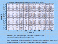
The bikes I sell. I found the steepest hill around and video'd me climbing them.The hill goes up, flatens a very little bit then steepens even more than the first bit. All bikes had to stand to pedal the very very steep bit at the end but all were able to pedal up them to completion. I have pedal'd this hill as a kid on an unassisted bike and could only ever make it about 2/3 of the way up.

Videos uploading now, please tell me the grade of the hill if you can. Highland road Saint John N.B.
http://youtube.com/watch?v=lU6-WEz22Nc
http://youtube.com/watch?v=lHol87Um7Yk

Look at other side of hill http://youtube.com/watch?v=9hRM15k0Qvk
 
Highland rd Saint John yes. That was both types of scooters. Large and small. The small one in video had very under inflated tires. Didn't notice I'd forgot to inflate em till I got to the hill with the bikes.

The van stopped so I kept going. Local ordinance says your not supposed to back out of a driveway onto a rd.

So no one can estimate the grade?
 
Use the water bottle technique somebody else posted. Partially fill a clear 2 liter; set it down on the road lengthwise; take a pic from ground level; post the pic.
 
Damn steep.

I get about 23%

:shock:
 
xyster said:
Use the water bottle technique somebody else posted. Partially fill a clear 2 liter; set it down on the road lengthwise; take a pic from ground level; post the pic.
This is lousy sampling technique. Ya can't say how representative that 8-10" patch of road (that the bottle is resting on) is versus the overall...

Try a 4' piece of clear plastic tube with water in it. Fasten to a 3' piece of wood so tube "loops" and the water level at each end is level w/the wood. Wood is then absolutely level. Add another wood piece bolted at one end (so opposite end can be raised/lowered) level with the water, and standing at the bottom of the hill, sight along this piece and move it down `til it lines up with the hilltop. Measure how far this piece is lower than the water level at the opposite end of the tube (from the bolted end.)

Hard to describe, but hopefully you get the idea. Calc the slope from the ratio of 3' to the inches the "sighting" piece is below the water level at the opposite end of the tube from the bolt end.

You could do something similar w/a plumb bob and dispense w/the fluid.

Or, like Ypedal said, borrow a GPS :)

tks

Lock
 
Lock said:
xyster said:
Use the water bottle technique somebody else posted. Partially fill a clear 2 liter; set it down on the road lengthwise; take a pic from ground level; post the pic.
This is lousy sampling technique. Ya can't say how representative that 8-10" patch of road (that the bottle is resting on) is versus the overall...

It's just a simple estimation tool. Look at the road and pick a representative patch, or take multiple readings at different points. A four-foot tube and 3 foot piece of wood is rather awkward to carry.

The rounded ends of the bottle also adds to the error.

Or get one of these over-priced inclinometers:
http://circlecitybicycles.com/inclin.htm
inclin2.jpg
 
I just used a carpenter's level and a tape measure. Still not very handy to carry around but fairly accurate. You still need to carefully pick a "representative" spot to measure. Measuring serveral spots and averaging the results would be more accurate. GPS elevation data is not that accurate, but it would be good over long distances.
 
xyster wrote:
Or get one of these over-priced inclinometers:
http://circlecitybicycles.com/inclin.htm

I got one of these, and it works great, except I have to stop to get a good reading. Even on the trike with it mounted on the bar just in front of the seat I can't usually safely concentrate on it long enough, plus the bubble moves around if you are not on real smooth pavement at a constant speed. Went up a steep hill the other day and could see that it was "pegged" at 21 degrees. Had to work hard with full power to maintain 10 MPH.
 
A four-foot tube and 3 foot piece of wood is rather awkward to carry.
Agree. I only used those measurements to give a sense of relative scale. The thing could be scaled down to six inches, but the larger the better, as larger will introduce smaller errors...

In theory, standing at the bottom of the hill and sighting at the top should provide a very accurate (average,overall) grade measurement, and cheap/easy to make too.

tks

Lock
 
The plumb-bob idea could work... very portable. (but not potable.)

The camera could be placed at about ground level, a few paces distance perpendicular to the roadway and plumb-bob. A self-timer shot could be taken whilst holding the bob's line from as high as possible (pole?).

Many feet of roadway and many feet of bob-line visible in the shot could be a reasonable sample.


(Getting a plumb utility pole in a picture might be easiest.)

8)
 
altimeter reading, or could a sextant work?
 
newbie electric rider said:
altimeter reading, or could a sextant work?
yes and yes :)
I believe though that altimeters work based on air pressure? affected by weather?
And a sextant? Expensive, so that's essentially what I propose with the tube and sticks!

Sextants just measure the angle above the horizon. And you can buy artificial horizons (bubbles in fluid) for sextants for when you can't see the horizon eg when practicing in doors. The purpose of the tube w/liquid.

Caveat here - my nav experience is all coastal piloting and not celestial! :wink: )

My understanding from reading the EV folks is that even a few degrees of elevation can be significant to energy consumption.

Lock
 
Lock said:
My understanding from reading the EV folks is that even a few degrees of elevation can be significant to energy consumption.

Here's a chart created from 'zotter data. The slope increases watts signficantly: At 25mph, a 5% slope will require double the watts of a 1% slope.
 

Attachments

  • slopeVmph1b.gif
    slopeVmph1b.gif
    32 KB · Views: 2,464
Watt he said!

Thanks for that Tyler.

It's amusing how adding batts makes one so much more aware of energy consumption...

I suspect that it may be "worse" than these figures, in that with power-assist the rider may be relying even more on the batts for the uphills than on the downs.

My standard commute is 11.72miles one way with a 401' rise/drop. (By coincidence, from beside one airport to beside a second airport, and airports publish their exact altitudes - in feet - above sea level!) I think this works out to about a 1% average slope.

I find I can get about 1/2 way up/to client before breakfast (slash opportunity charge), but all the way back (down/home) on one charge... so that'd be about twice the energy for a 2% diff. in slope?

`Course, a new vehicle packing Lithium will obviate the need for the opportunity charge... but I'll still stop/breakfast/plugin anyway, `cause this gets so many sidewalk/patio conversations started about EVs and power-assist!

tks

Lock
 
I suspect that it may be "worse" than these figures, in that with power-assist the rider may be relying even more on the batts for the uphills than on the downs.

Since efficiency falls off at low rpms, and acceleration itself requires additional power, those numbers should be about doubled when considering the power required to get up the hill when starting from a stop, or a slow speed -- like from a stop light at the bottom. The situation is worst for systems with only one gear, and the reason folks who ride hills, don't want to pedal like mad, and are considering anything besides a cyclone-type ebike (that puts the motor power through the regular gear clusters) would be well-served to double their estimate of power needed.
 
H - if we have the money for $ 500 batteries you would think we could afford this. :wink:

http://www.amazon.com/VDO-Wired-Bicycle-Computer-Altimeter/dp/B000932H5E
 
Back
Top