GPS overlay on video

brainfarth

100 mW
Joined
Feb 16, 2013
Messages
45
Location
Oregon City, Oregon
I've seen a few videos on youtube, where they have overlayed GPS data in the form of speedometers, elevation and direction on their video. Does anyone have any recommendations for an android app that can record and export this data so I can drop it on my videos?
 
The videos were probably done with a GPS enabled camera. There are some of those for motorsports.

I'm not sure if there is an app that can do that, but I don't see why not. If there isn't anything out there, it could be a decent development opportunity
 
LSBW said:
Or just get Sony HDR-AS100V.

[youtube]RHjpPIM6QA8[/youtube]

OOOOhh... I like that one. $200 is actually not a bad price
 
Yep. I've spent tons of time, trying to overlay video from my Gopro and GPS data from my smartphone, bought an actual app for that.
It's not easy, time consuming and just waste of time. If you don't have cam yet, get one with GPS built-in.
 
I have the Sony AS20 and it's a great cam for the price. Seems that the AS30 has the GPS option for information overlay. Even though it's an interesting prospect, you are still limited to their format. An app would be more flexible answer.
 
There's other cameras too that can do it. I got this one:

http://www.myactioncamera.co.uk/shop/cameras/ac32-sport-plus/

This is what it shows you. It syncs your video with the map and GPS data.
 

Attachments

  • wrekin.jpg
    wrekin.jpg
    138.2 KB · Views: 2,743
  • camera.jpg
    camera.jpg
    162.4 KB · Views: 2,741
I've done this on a number of my video's using my Oregon Scientific ATC9K Action cam. This camera also includes a G sensor which sounds nice on paper, but pointless in the way they implemented it in this camera.
http://endless-sphere.com/forums/viewtopic.php?f=6&t=51042
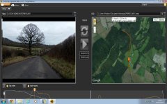
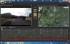
The big catch with this camera is the only (easy) way to get the stats and Map are using the (really) crappy Oregon Scientific software that interfaces with the files made by the camera with this info in them.
In order to get my video's the way I want, I have to manually take a screen capture video in real time of the informational section of the recording playing back in the crappy software. Then when I start editing together my video I overlay the 2 (or 3 or 4) videos together and (try to) match up the start points. Sometimes it gets out of sync, especially when I add in Slow-mo footage.
The advantage of doing it this way is I have complete control of what, where and when I display the stats or map.

I've experimented with a few different positions and what info I do/ don't include. Here's a few examples from my thread:
[youtube]pwAJMIFq_1w[/youtube]
[youtube]O08bEM9PA-Q[/youtube]
[youtube]KP6ZopBLQeU[/youtube]

Cheers
 
An update: I figured out which app to use for your phone and how to overlay it on any video you might have.
Use this to log all of your data: GPS Logger Android App by Tech Universe Solutions Inc https://goo.gl/pPw8B4
And this is the program that you can overlay the data onto your video: Dashware (Use the Dashware Logger profile when importing the data) Dashware.net
After you have synced your video and GPS data, render the video and edit it in your favorite editor.
https://www.youtube.com/watch?v=NGGaeh1KyjA
[youtube]NGGaeh1KyjA[/youtube]
 
Back
Top