
You are using an out of date browser. It may not display this or other websites correctly.
You should upgrade or use an alternative browser.
You should upgrade or use an alternative browser.
El Niño in the newz. Again.
- Thread starter LockH
- Start date
Season total is 32.2" so far. This is almost exactly the same as this time last year. But we got a lot of rain in March last year and the end total was around 46".
The fingers
10 TW
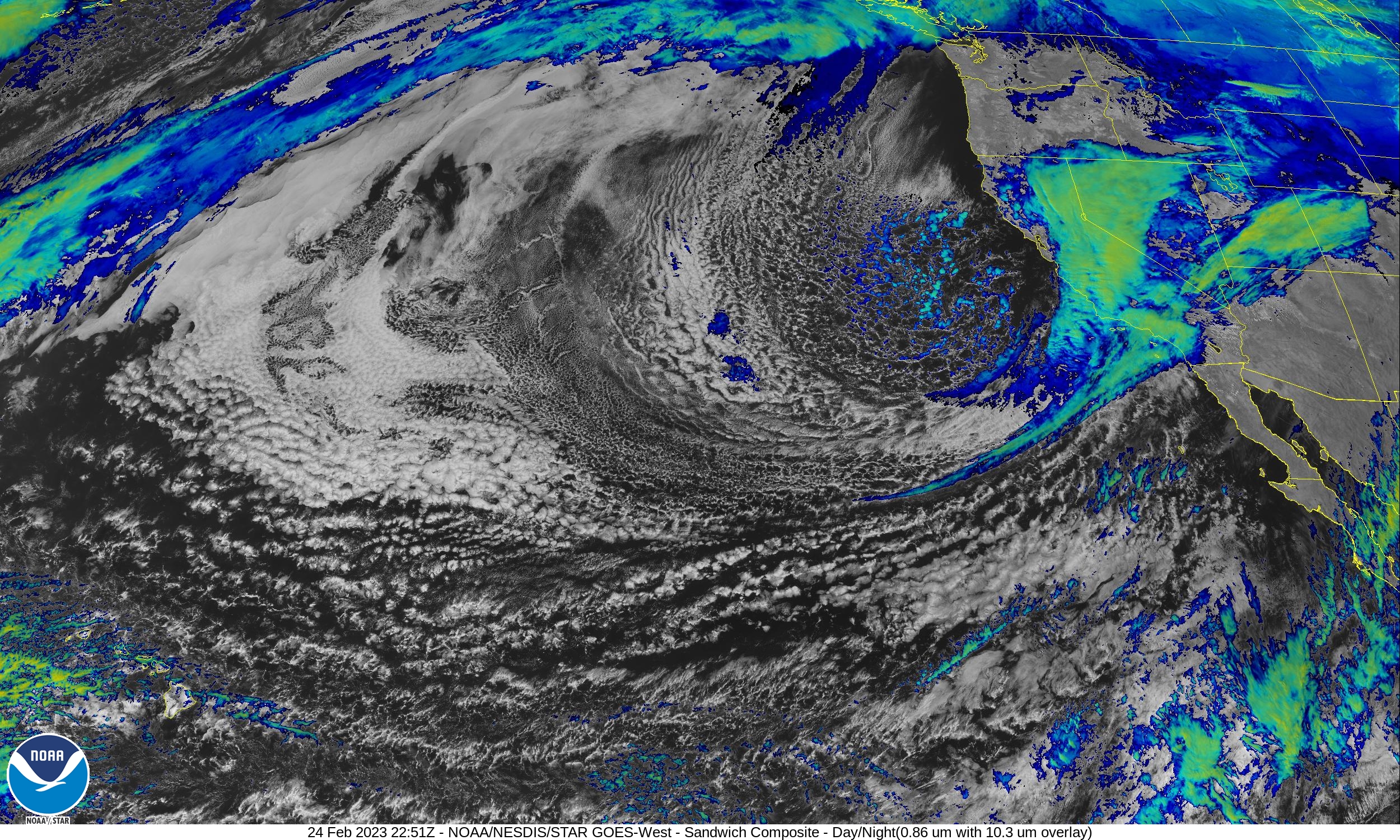
GOES-West CONUS - Sandwich - NOAA / NESDIS / STAR
Near real-time publication of GOES-East and GOES-West images from NOAA/NESDIS/STAR
Weaker weather system for the beginning of next week. It’s followed by a stronger, colder one after that. We’ll take all that we can get.
Detailed Forecast
TonightMostly cloudy, with a low around 53. Calm wind.
Sunday
Partly sunny, with a high near 72. Calm wind becoming west around 5 mph in the afternoon.
Sunday Night
Mostly cloudy, with a low around 49. East wind around 5 mph becoming calm.
Monday
A slight chance of showers after 10am. Mostly cloudy, with a high near 64. Light west wind increasing to 5 to 10 mph in the afternoon. Chance of precipitation is 20%.
Monday Night
A chance of showers. Mostly cloudy, with a low around 47. West wind around 5 mph becoming east in the evening. Chance of precipitation is 40%. New precipitation amounts of less than a tenth of an inch possible.
Tuesday
A chance of showers before 10am. Partly sunny, with a high near 61. Chance of precipitation is 30%.
Tuesday Night
Partly cloudy, with a low around 45.
Wednesday
Sunny, with a high near 67.
Wednesday Night
Mostly clear, with a low around 46.
Thursday
Sunny, with a high near 66.
Thursday Night
Partly cloudy, with a low around 45.
Friday
Mostly sunny, with a high near 63.
Friday Night
A slight chance of showers. Mostly cloudy, with a low around 45.
Saturday
A chance of showers. Partly sunny, with a high near 57.
Last edited:
The fingers
10 TW
El Nino Rain Gage
Nothin'/Skunked-Foggy Doggy-Play Misty-Drizzle Corn-Light Showers-Steady Soaker-Bands/Sheets-Cats & Dogs
*****************************************************************************")
Nothin'/Skunked-Foggy Doggy-Play Misty-Drizzle Corn-Light Showers-Steady Soaker-Bands/Sheets-Cats & Dogs
*****************************************************************************
Thought we were just going to have a humid day, but the moment I opened the laptop on the back of the trike while doing some troubleshooting, and got down on the ground to plug in the usb-serial cable from it to the Phaserunner, the sprinkles started with big fat drops. As soon as I managed to haul myself back up with the cane and close the laptop lid, less than 30 seconds later, the rain stopped and hasn't restarted since.
The fingers
10 TW
Only 0.03” this evening, 20% chance tonight and tomorrow. Barring an odd thunderstorm looks like we got a dud. Still better than nothing.
The fingers
10 TW
0.02” overnight brings the total to 0.05” for this storm here with many mostly mountain locations getting more as the system moves to the east. The center of the low remains near the Channel Islands giving a slight chance to add a little more later this morning.
 www.star.nesdis.noaa.gov
Edit:
www.star.nesdis.noaa.gov
Edit:
Baja California, AZ, Old and New Mexico still getting some moisture out of it as the cut off low finally moves ashore and dissipates while the system moves east into TX.
 www.wpc.ncep.noaa.gov
GOES-West CONUS - Sandwich - NOAA / NESDIS / STAR
Near real-time publication of GOES-East and GOES-West images from NOAA/NESDIS/STAR
Baja California, AZ, Old and New Mexico still getting some moisture out of it as the cut off low finally moves ashore and dissipates while the system moves east into TX.
Weather Prediction Center (WPC) Home Page
Last edited:
The fingers
10 TW
National Weather Service:
Today
Mostly sunny, with a high near 64. Southwest wind 5 to 10 mph.
Wonkuuweather:
A shower in spots late this morning; otherwise, low clouds and fog breaking for some sun.
40%
Guess who I believe? Looks like the rain is still coming at least a day away. Trust the official forecast folks; the NWS usually gets it right. Just the usual late night and early morning low clouds and fog.
www.star.nesdis.noaa.gov
Today
Mostly sunny, with a high near 64. Southwest wind 5 to 10 mph.
Wonkuuweather:
A shower in spots late this morning; otherwise, low clouds and fog breaking for some sun.
40%
Guess who I believe? Looks like the rain is still coming at least a day away. Trust the official forecast folks; the NWS usually gets it right. Just the usual late night and early morning low clouds and fog.
GOES-West CONUS - Sandwich - NOAA / NESDIS / STAR
Near real-time publication of GOES-East and GOES-West images from NOAA/NESDIS/STAR
Drizzle/light rain all day here. About 1/4" so far. Up in the Sierras it's supposed to be a major blizzard with 10 FEET of snow in some places. Interstate 80 is going to be a mess for a while.
The fingers
10 TW
Detailed Forecast
TonightPatchy drizzle with a slight chance of rain after 10pm. Patchy fog after 10pm. Otherwise, mostly cloudy, with a low around 47. Southwest wind 5 to 10 mph. Chance of precipitation is 20%.
Friday
Patchy drizzle with a slight chance of rain before 10am, then a chance of rain, mainly after 4pm. Patchy fog before 10am. Otherwise, partly sunny, with a high near 60. Light and variable wind becoming west 5 to 10 mph in the morning. Chance of precipitation is 30%. New precipitation amounts of less than a tenth of an inch possible.
Friday Night
A chance of rain before 10pm, then patchy drizzle with a chance of showers after 10pm. Patchy fog after 10pm. Otherwise, mostly cloudy, with a low around 48. Southwest wind 5 to 10 mph, with gusts as high as 20 mph. Chance of precipitation is 50%. New precipitation amounts of less than a tenth of an inch possible.
Saturday
Showers likely with patchy drizzle before 10am, then showers likely after 10am. Patchy fog before 10am. Otherwise, mostly cloudy, with a high near 56. Southwest wind 10 to 15 mph, with gusts as high as 25 mph. Chance of precipitation is 70%. New precipitation amounts between a tenth and quarter of an inch possible.
Saturday Night
Showers likely before 10pm, then patchy drizzle with a chance of showers after 10pm. Patchy fog after 10pm. Otherwise, mostly cloudy, with a low around 44. Southwest wind 5 to 10 mph. Chance of precipitation is 60%. New precipitation amounts of less than a tenth of an inch possible.
Sunday
Patchy drizzle with a chance of showers before 10am, then a slight chance of showers after 10am. Patchy fog before 10am. Otherwise, mostly cloudy, with a high near 55. Chance of precipitation is 30%.
Sunday Night
A slight chance of showers before 10pm. Mostly cloudy, with a low around 41. Chance of precipitation is 20%.
Monday
Mostly sunny, with a high near 57.
Monday Night
Partly cloudy, with a low around 40.
Tuesday
Mostly sunny, with a high near 62.
Tuesday Night
Partly cloudy, with a low around 42.
Wednesday
Mostly sunny, with a high near 60.
Wednesday Night
Partly cloudy, with a low around 43.
Thursday
A slight chance of rain. Mostly sunny, with a high near 61.
The fingers
10 TW
The fingers
10 TW
El Nino Rain Gage
Nothin'/Skunked-Foggy Doggy-Play Misty-Drizzle Corn-Light Showers-Steady Soaker-Bands/Sheets-Cats & Dogs
*****************************************************************************
Just 0.06” of rain fell this morning. So far this storm is a dud. On the news they’re showing clips of the last big storm because they have nothing else. The same huge waves that happened weeks ago and a landslide over a week old.
Just had a very brief shower of a minute or so followed by the sun coming out.
Last edited:
e-beach
10 MW
Mean while at Lake Tahoe...
A gust of 190 mph was detected Friday night at Palisades Tahoe at an elevation of 8,700 feet, according to the National Weather Service. Forecasters warned of extreme avalanche danger across the Tahoe region in the Sierra backcountry through Sunday afternoon......
Over 1.5" here since Wednesday. Still getting brief showers here and there. The wind made a mess in the yard again, so something to do once it stops raining.
The fingers
10 TW
0.10” additional this evening making the storm total 0.16” so far. Still a 50% chance so could be some more.
The fingers
10 TW
Only 0.01” overnight giving us a 0.17” storm total here from the “storm of the year”. No atmospheric river for this area.
The fingers
10 TW
National Weather Service
The fingers
10 TW
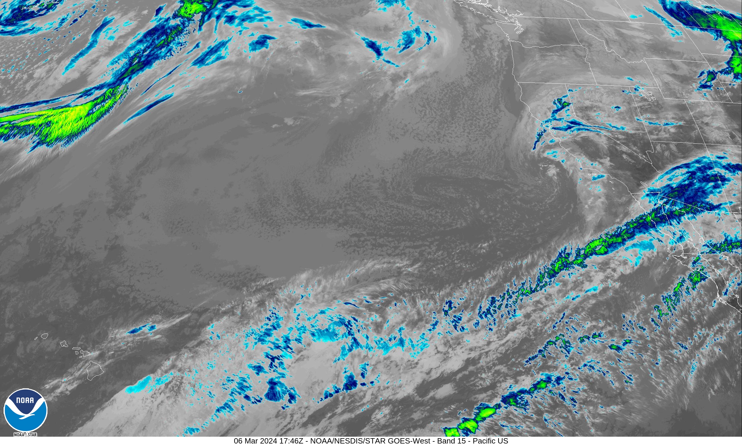
The satellite view of the next low approaching the coast shows the sub-tropical jet stream staying to the south so we’re not expecting too much from the next storm.
 www.star.nesdis.noaa.gov
GOES-West CONUS - Band 15 - NOAA / NESDIS / STAR
Near real-time publication of GOES-East and GOES-West images from NOAA/NESDIS/STAR
Another 0.5" overnight. Looking for a break in the rain....
The fingers
10 TW
El Nino Rain Gage
Nothin'/Skunked-Foggy Doggy-Play Misty-Drizzle Corn-Light Showers-Steady Soaker-Bands/Sheets-Cats & Dogs
***************************************************************************
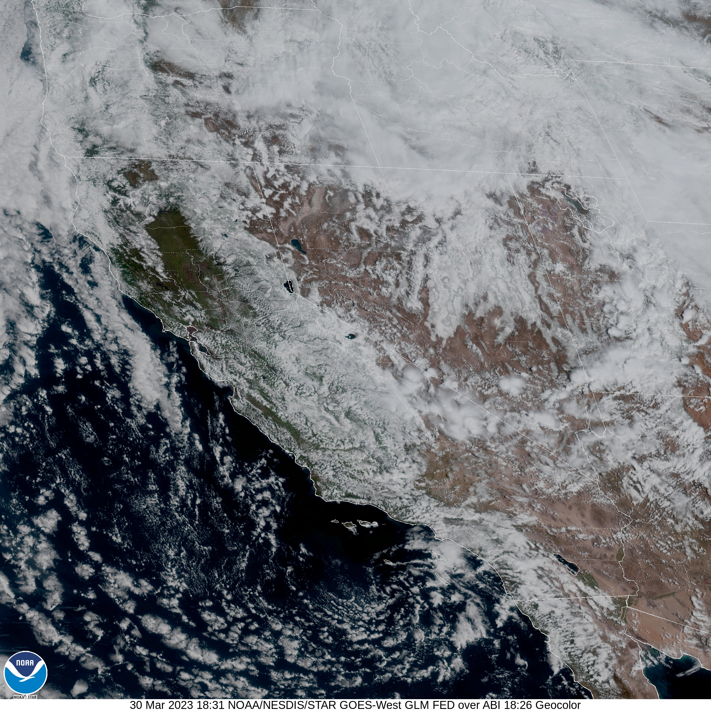
Nothing in the rain gage yet. Radar looks spotty at best. Jaccuweather:
Unstable air moves ashore so there’s some hope:
 www.star.nesdis.noaa.gov
www.wpc.ncep.noaa.gov
www.star.nesdis.noaa.gov
www.wpc.ncep.noaa.gov
Nothin'/Skunked-Foggy Doggy-Play Misty-Drizzle Corn-Light Showers-Steady Soaker-Bands/Sheets-Cats & Dogs
***************************************************************************
Nothing in the rain gage yet. Radar looks spotty at best. Jaccuweather:
Unstable air moves ashore so there’s some hope:
GOES-West - Sector view: Pacific Southwest - Geostationary Lightning Mapper - NOAA / NESDIS / STAR
Near real-time publication of GOES-East and GOES-West images from NOAA/NESDIS/STAR
Weather Prediction Center (WPC) Home Page
Last edited:
The fingers
10 TW
Just 0.06” this evening, maybe we’ll get a little more overnight.
The fingers
10 TW
0.16” fell in the mid-night hours for a storm total of 0.22” so far.

The fingers
10 TW
Detailed Forecast
OvernightShowers likely. Mostly cloudy, with a low around 44. Southeast wind around 5 mph. Chance of precipitation is 60%. New precipitation amounts of less than a tenth of an inch possible.
Thursday
A slight chance of showers, then a chance of showers and thunderstorms after 1pm. Some of the storms could produce heavy rainfall. Partly sunny, with a high near 58. Light and variable wind becoming west 5 to 10 mph in the afternoon. Chance of precipitation is 30%. New rainfall amounts between a tenth and quarter of an inch, except higher amounts possible in thunderstorms.
Thursday Night
A chance of showers and thunderstorms before 7pm, then a chance of showers between 7pm and 10pm. Some of the storms could produce heavy rainfall. Mostly cloudy, with a low around 43. South wind around 5 mph becoming calm in the evening. Chance of precipitation is 40%. New precipitation amounts between a tenth and quarter of an inch, except higher amounts possible in thunderstorms.
Friday
Mostly sunny, with a high near 68. Calm wind becoming west around 5 mph.
Friday Night
Mostly clear, with a low around 45. South wind around 5 mph becoming calm in the evening.
Saturday
Sunny, with a high near 69.
Saturday Night
Mostly clear, with a low around 45.
Sunday
Mostly sunny, with a high near 69.
Sunday Night
Partly cloudy, with a low around 45.
Monday
Mostly sunny, with a high near 64.
Monday Night
Partly cloudy, with a low around 46.
Tuesday
Mostly sunny, with a high near 65.
Tuesday Night
Partly cloudy, with a low around 47.
Wednesday
Mostly sunny, with a high near 68.
The fingers
10 TW
Edit:
Got 0.11” today in the gage. We need a thunderstorm to liven things up. Storm total here now 0.33” as of 5:00 pm.
Some dark clouds to the west might add to the total.
Might get my wish:
Got 0.11” today in the gage. We need a thunderstorm to liven things up. Storm total here now 0.33” as of 5:00 pm.
Some dark clouds to the west might add to the total.
Might get my wish:
Last edited:
The fingers
10 TW
Another 0.06” fell giving a total of 0.39”
Similar threads
- Replies
- 36
- Views
- 9,583
- Replies
- 14
- Views
- 3,483
- Replies
- 146
- Views
- 33,379