You are using an out of date browser. It may not display this or other websites correctly.
You should upgrade or use an alternative browser.
You should upgrade or use an alternative browser.
la Nina rears her ugly head
- Thread starter Dauntless
- Start date
ZeroEm
1 MW
by fechter » Jun 11 2021 8:47am
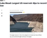
Lake Mead - Have been watching this for a least five years now. Even while it completely dry's up they will not put on restrictions until next year. I do not understand ignoring the problem until it is out of control.
San Antonio, Tx (current residence) is looking like a dividing line between the flooding and the drought. Last year received 2/3 of our annual ran fall which is 32". This year we have received 20" in three months march-may. When the line moves a little west, cooler and wetter than normal, a little east, hotter and dryer than normal. They can forget using history as a pattern, it's all new.
The fingers
10 TW
https://m.youtube.com/watch?v=9CRbEvrOqcs&feature=youtu.be 
The fingers
10 TW
https://www.accuweather.com/en/us/hemet/92543/daily-weather-forecast/337079 
The fingers
10 TW
https://m.youtube.com/watch?v=ASXsMz3T3Qk
https://storymaps.arcgis.com/stories/c3069eb0f2564474bd7c43cb72d9f2e0
https://storymaps.arcgis.com/stories/c3069eb0f2564474bd7c43cb72d9f2e0
The fingers
10 TW
https://m.youtube.com/watch?v=n7NrZMgG5x4&feature=youtu.be
The fingers
10 TW
A brief sprinkle this am, just a few drops. :|
https://radar.weather.gov/?settings=v1_eyJhZ2VuZGEiOnsiaWQiOiJuYXRpb25hbCIsImNlbnRlciI6Wy0xMTYuNjUyLDMzLjA4N10sInpvb20iOjcsImxheWVyIjoiY3JlZl9xY2QiLCJ0cmFuc3BhcmVudCI6dHJ1ZSwiYWxlcnRzT3ZlcmxheSI6dHJ1ZX0sImJhc2UiOiJzdGFuZGFyZCIsImNvdW50eSI6ZmFsc2UsImN3YSI6ZmFsc2UsInN0YXRlIjpmYWxzZSwibWVudSI6dHJ1ZSwic2hvcnRGdXNlZE9ubHkiOnRydWV9#/
https://radar.weather.gov/?settings=v1_eyJhZ2VuZGEiOnsiaWQiOiJuYXRpb25hbCIsImNlbnRlciI6Wy0xMTYuNjUyLDMzLjA4N10sInpvb20iOjcsImxheWVyIjoiY3JlZl9xY2QiLCJ0cmFuc3BhcmVudCI6dHJ1ZSwiYWxlcnRzT3ZlcmxheSI6dHJ1ZX0sImJhc2UiOiJzdGFuZGFyZCIsImNvdW50eSI6ZmFsc2UsImN3YSI6ZmFsc2UsInN0YXRlIjpmYWxzZSwibWVudSI6dHJ1ZSwic2hvcnRGdXNlZE9ubHkiOnRydWV9#/
The fingers
10 TW
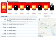
Detailed Forecast
Overnight
Mostly clear, with a low around 73. Calm wind.
Saturday
Sunny, with a high near 101. Light northwest wind becoming west 5 to 10 mph in the morning.
Saturday Night
Clear, with a low around 74. Northwest wind around 5 mph becoming north after midnight.
Sunday
Sunny, with a high near 101. North wind 5 to 10 mph becoming west 10 to 15 mph in the afternoon. Winds could gust as high as 25 mph.
Sunday Night
Clear, with a low around 69. North wind 5 to 10 mph becoming light and variable after midnight. Winds could gust as high as 20 mph.
Monday
Sunny, with a high near 92.
Monday Night
Mostly clear, with a low around 64.
Tuesday
Sunny, with a high near 90.
Tuesday Night
Mostly clear, with a low around 62.
Wednesday
Sunny, with a high near 88.
Wednesday Night
Clear, with a low around 61.
Thursday
Sunny, with a high near 90.
Thursday Night
Mostly clear, with a low around 64.
Friday
Sunny, with a high near 95.
After this relief it’s supposed to heat up again next weekend.
The fingers
10 TW
Wednesday
A chance of showers and thunderstorms. Some of the storms could produce gusty winds. Partly sunny, with a high near 88. Light west wind increasing to 5 to 10 mph in the morning. Chance of precipitation is 30%. New rainfall amounts of less than a tenth of an inch, except higher amounts possible in thunderstorms.
A chance of showers and thunderstorms. Some of the storms could produce gusty winds. Partly sunny, with a high near 88. Light west wind increasing to 5 to 10 mph in the morning. Chance of precipitation is 30%. New rainfall amounts of less than a tenth of an inch, except higher amounts possible in thunderstorms.
The fingers
10 TW
Another brief sprinkle this pm, just a few drops. :|
https://www.accuweather.com/en/us/hemet/92543/weather-radar/337079
https://www.accuweather.com/en/us/hemet/92543/weather-radar/337079
The fingers
10 TW
The fingers
10 TW
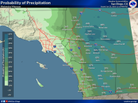
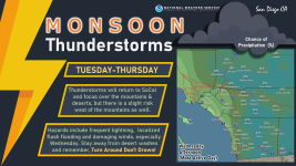
Thunderstorms to the east, south and west of San Diego as monsoon moisture moves into the area. Zoom in on the right side of the PACUS satellite view.
https://www.star.nesdis.noaa.gov/GOES/conus_band.php?sat=G17&band=EXTENT&length=24
Southland radar from the local ABC affiliate:
https://abc7.com/weather/doppler/southland-overview/
Detailed Forecast
Overnight
A chance of showers and thunderstorms. Mostly cloudy, with a low around 66. Calm wind. Chance of precipitation is 30%.
Wednesday
A chance of showers and thunderstorms. Partly sunny, with a high near 92. Light northwest wind becoming southwest 5 to 10 mph in the morning. Chance of precipitation is 40%.
The fingers
10 TW
La Niña Rain Gage
Nothin'/Skunked-Foggy Doggy-Play Misty-Drizzle Corn-Light Showers-Steady Soaker-Bands/Sheets-Cats & Dogs
******************************************************************
Nothin'/Skunked-Foggy Doggy-Play Misty-Drizzle Corn-Light Showers-Steady Soaker-Bands/Sheets-Cats & Dogs
******************************************************************
Not a drop here since winter. Things are getting really dried out. July 4 is going to be pretty risky.
The fingers
10 TW
Detailed Forecast
Today
Sunny, with a high near 101. Calm wind becoming west around 5 mph in the afternoon.
Tonight
Clear, with a low around 70. West wind around 5 mph becoming calm in the evening.
Sunday
Sunny, with a high near 105. Calm wind becoming west around 5 mph in the afternoon.
Sunday Night
Mostly clear, with a low around 72. Light and variable wind becoming northeast 5 to 10 mph in the evening.
Monday
Sunny, with a high near 104. Light and variable wind becoming west 10 to 15 mph in the afternoon. Winds could gust as high as 20 mph.
Monday Night
Partly cloudy, with a low around 70.
Tuesday
A slight chance of showers and thunderstorms after 11am. Mostly sunny, with a high near 99. Chance of precipitation is 20%.
Tuesday Night
A chance of showers and thunderstorms. Partly cloudy, with a low around 69.
Wednesday
A chance of showers and thunderstorms. Mostly sunny, with a high near 94.
Wednesday Night
A chance of showers and thunderstorms. Partly cloudy, with a low around 68.
Thursday
A chance of showers and thunderstorms. Mostly sunny, with a high near 94.
Thursday Night
Mostly clear, with a low around 67.
Friday
Sunny, with a high near 96.
Hillhater
100 TW
Copied from another thread...but very relavent..
Studies of Tree rings have identified a pattern of “Megadroughts” on the US West coast.
https://www.kqed.org/science/1962273/me ... ntists-say
.
...And its about 400 yrs since the last one !
Studies of Tree rings have identified a pattern of “Megadroughts” on the US West coast.
https://www.kqed.org/science/1962273/me ... ntists-say
.
Suggesting there is a 400yr cycle of these natural events.....The last time the West experienced sustained arid conditions over decades was a 28-year dry spell that ended in the year 1603, researchers say.
“We now have a full, uninterrupted record of soil moisture across western North America that extends from 800 A.D. all the way up to the near present,” said Park Williams, a bioclimatologist at Lamont-Doherty Earth Observatory at Columbia University, who led the study. “That allows us to compare for the first time this drought event to the big megadroughts. And the development of this prolonged drought that began in 2000 looks indistinguishable from those big megadroughts.”
The study looked at California, eight other states and Northern Mexico.
A Worst-Case Scenarios for Water Managers
Scientists have long known that the West suffered in the distant past under anomalous dry periods that lasted for decades.
The region returning to what researchers call a megadrought or a “paleo-drought” is considered to be a worst-case scenario for water managers.
Researchers say the region experienced megadroughts in the 9th, 12th, 13th and16th centuries, disrupting Native American cultures. For example, dry conditions are believed to have driven the Anasazi from their pueblo settlements in Arizona, New Mexico, Colorado and Utah.
...And its about 400 yrs since the last one !
The fingers
10 TW
Tuesday
A chance of showers and thunderstorms after 11am. Increasing clouds, with a high near 99. Light northwest wind becoming west 5 to 10 mph in the afternoon. Chance of precipitation is 30%. New rainfall amounts of less than a tenth of an inch, except higher amounts possible in thunderstorms.
Tuesday Night
A chance of showers and thunderstorms, mainly before 11pm. Mostly cloudy, with a low around 70. Chance of precipitation is 30%.
Wednesday
A chance of showers and thunderstorms, mainly after 11am. Partly sunny, with a high near 95. Chance of precipitation is 40%.
Wednesday Night
A chance of showers and thunderstorms. Partly cloudy, with a low around 69.
Thursday
A chance of showers and thunderstorms, mainly after 11am. Mostly sunny, with a high near 95.
The fingers
10 TW
The fingers
10 TW
Tuesday
A slight chance of showers and thunderstorms after 11am. Mostly sunny, with a high near 102. Calm wind becoming west around 5 mph in the afternoon. Chance of precipitation is 20%.
Tuesday Night
A slight chance of showers and thunderstorms before 11pm. Partly cloudy, with a low around 68. West wind around 5 mph becoming calm in the evening. Chance of precipitation is 20%.
Wednesday
A slight chance of showers and thunderstorms after 11am. Partly sunny, with a high near 97. Light and variable wind becoming west 5 to 10 mph in the afternoon. Chance of precipitation is 20%.
Diminishing shower chances drying up our hopes of a shower. :|
The fingers
10 TW
markz
100 TW
(When it rains and shines) It's just a state of mind
Rain
I don't mind
[youtube]cK5G8fPmWeA[/youtube]
Rain
I don't mind
[youtube]cK5G8fPmWeA[/youtube]
The fingers
10 TW
La Niña Rain Gage
Nothin'/Skunked-Foggy Doggy-Play Misty-Drizzle Corn-Light Showers-Steady Soaker-Bands/Sheets-Cats & Dogs
***
Nothin'/Skunked-Foggy Doggy-Play Misty-Drizzle Corn-Light Showers-Steady Soaker-Bands/Sheets-Cats & Dogs
***
The fingers
10 TW
The fingers
10 TW
https://m.youtube.com/watch?v=1mDV3h3dkPc&feature=youtu.be
Similar threads
- Replies
- 10
- Views
- 3,494


