la Nina rears her ugly head

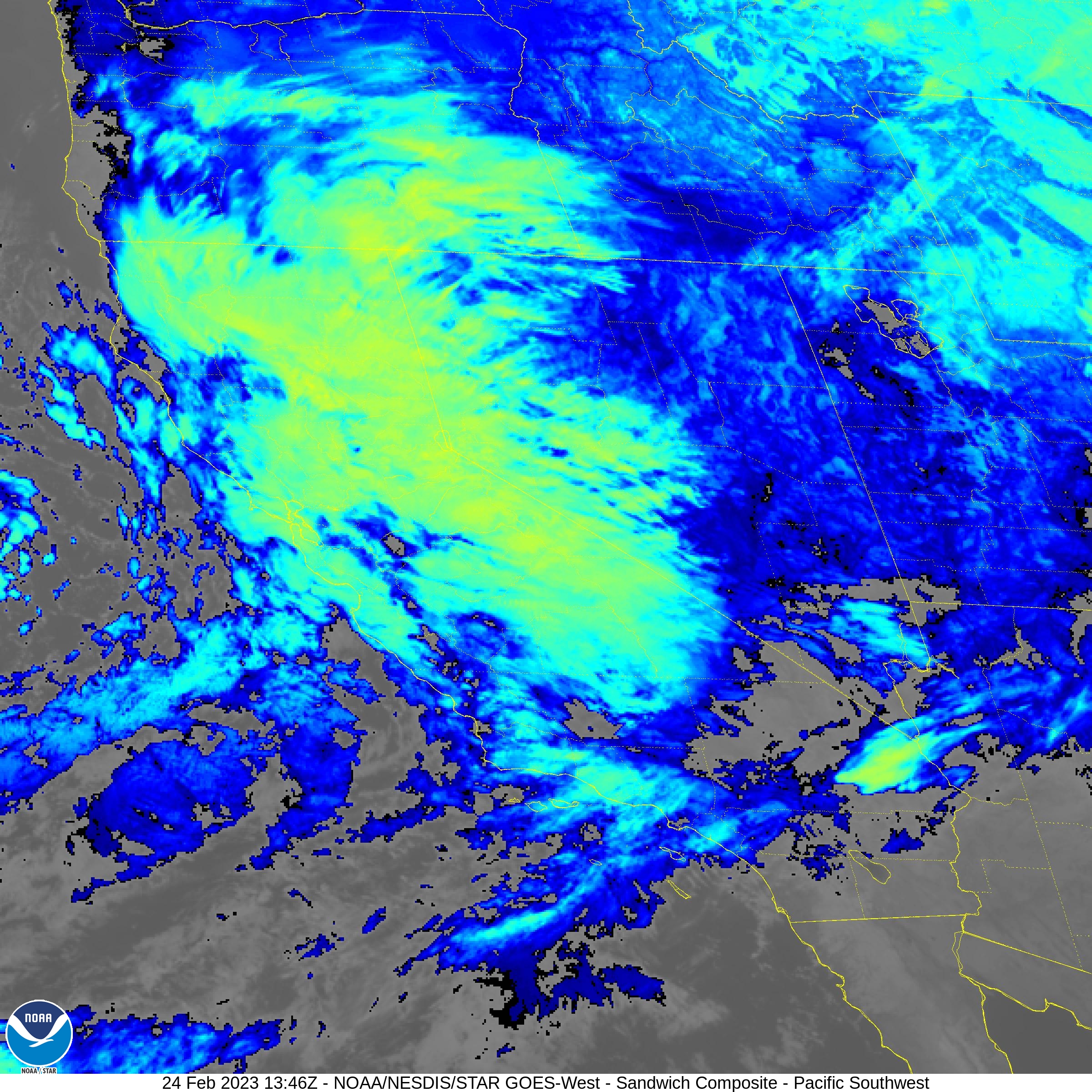
About another 4.5" since last report, so almost 9" since Wednesday. Some place a bit north of here reported over 21" since Wednesday. And just to the south in San Jose, they got almost nothing.
I managed to stay in the Goldilocks zone. No flooding or damage but plenty of rain. The ground is pretty much saturated now, so there should be some good flows going into the reservoirs.
 
Weather.gov says that we got 0.03” overnight so technically not a skunk but that was some forecast by network news. Where more often than not it’s delivered by a meteorologist with fake boobs or wearing a toupee riding overnight on a horse named Atmospheric River through a Big Bang Bomb Cyclone shouting “La Niña is coming! La Niña is coming!”
:LOL:
 
Last edited:

Detailed Forecast​

Overnight
Partly cloudy, with a low around 45. Calm wind.
Monday
Mostly sunny, with a high near 70. Calm wind becoming west around 5 mph in the afternoon.
Monday Night
Partly cloudy, with a low around 49. Calm wind.
Tuesday
A slight chance of showers. Partly sunny, with a high near 66. Calm wind becoming west around 5 mph in the afternoon. Chance of precipitation is 20%.
Tuesday Night
A chance of showers, mainly after 10pm. Patchy fog after 10pm. Otherwise, mostly cloudy, with a low around 52. West wind around 5 mph becoming calm. Chance of precipitation is 30%. New precipitation amounts of less than a tenth of an inch possible.
Wednesday
A chance of showers, mainly before 4pm. Mostly cloudy, with a high near 67. Chance of precipitation is 40%.
Wednesday Night
A slight chance of showers before 10pm. Mostly cloudy, with a low around 48. Chance of precipitation is 20%.
Thanksgiving Day
Partly sunny, with a high near 71.
Thursday Night
Mostly cloudy, with a low around 51.
Friday
A slight chance of showers after 10am. Mostly cloudy, with a high near 70.
Friday Night
A chance of showers. Mostly cloudy, with a low around 50.
Saturday
A chance of showers. Partly sunny, with a high near 69.
Saturday Night
Partly cloudy, with a low around 49.
Sunday
Mostly sunny, with a high near 72.
 
It's not bone dry here, but .02 inches in the last 2 months is not a grand start to the rainy season here.
 
About an inch here yesterday. More coming tonight. There are coastal flood advisories out for high tides combined with runoff. There are some places near the bay shore that flood easily, including the main bike trail that runs along highway 101 in Mill Valley.
 
About 3" overnight and some serious wind.

San Francisco's first-ever tornado warning ends.
Hundreds of thousands of San Francisco residents were jolted awake early Saturday morning by the first tornado warning ever issued for the city. It lasted about 20 minutes before ending at around 6:10 a.m.

It was not immediately clear whether a tornado had struck, but trees and wires were down in the city. San Francisco International Airport reported its strongest wind gust in nearly 50 years.
The tornado warning was due to an indication of a rotation off the coast around 6 a.m., which was traveling rapidly toward the western edge of the city near Ocean Beach and San Francisco State University, though the cell’s exact location was unclear — prompting an alert for the whole city.

The second punch to this system is underway now. That means strong winds and heavy rain are breaking out again, with wind gusts of up to 50 m.p.h. until around 11 a.m. and some gusts potentially higher in certain spots.

As of 6:50 a.m. there were 40,300 customers without power across San Francisco in the Bay Area, according to PG&E, including 14,744 in San Francisco and 17,337 in the Peninsula. Across PG&E's service territory, about 110,200 customers were without power shortly before 8 a.m. An 83 mph wind gust was recorded at San Francisco International Airport at 6:09 a.m. this morning as the strong cold front passed through. It was the second-strongest wind gust measured at SFO since records began in 1945. SFO's record strongest wind gust was 84 mph from June 15, 1977.
 
Funny what a few hundred miles will do. Bright and sunny here. Cool but could be 75°F here by Wednesday. 🤔
 
Another 0.7" on Monday. I'm taking advantage of the break to do some repairs on the house before the next system arrives. One of the drains for the back yard was clogged up and needed a good cleanout. Also looks like I have another small leak in the roof.
 
Another 0.25" last night. I took advantage of a break in the rain to go riding yesterday. Nice to not have dusty roads. There were some serious erosion features on the trail in places. This had just been bulldozed earlier in the season, but now looks pretty bad.
Luckily there's enough room to ride around it. A fire truck will have a harder time.

1736008409885.png
 
If we've had a drop of rain in the "OC" I missed it (probably < 0.1" in the "season" (Oct 1- Sep 30).
 

Detailed Forecast​

Overnight
Mostly clear, with a low around 43. Calm wind becoming east around 5 mph.
Tuesday
Sunny, with a high near 65. Light east wind becoming northeast 10 to 15 mph in the afternoon. Winds could gust as high as 25 mph.
Tuesday Night
Areas of blowing dust. Clear, with a low around 42. Windy, with a northeast wind 15 to 20 mph increasing to 25 to 30 mph after midnight. Winds could gust as high as 40 mph.
Wednesday
Areas of blowing dust. Sunny, with a high near 64. Windy, with a northeast wind 35 to 40 mph decreasing to 25 to 30 mph in the afternoon. Winds could gust as high as 55 mph.
Wednesday Night
Mostly clear, with a low around 41. East wind 10 to 15 mph, with gusts as high as 25 mph.
Thursday
Sunny, with a high near 71. Breezy.
Thursday Night
Clear, with a low around 41.
Friday
Sunny, with a high near 68.
Friday Night
Clear, with a low around 40.
Saturday
Sunny, with a high near 70.
Saturday Night
Clear, with a low around 41.
Sunday
Sunny, with a high near 66.
Sunday Night
Mostly clear, with a low around 38.
Monday
Sunny, with a high near 64.
 
And those winds helped burn down the houses of three of my friends in the Pacific Palisades. (the Palisade fire) I have two good friends who grew up in the Palisades. They have dozens of friends who's houses burnt to the ground. The winds were so heavy that they blew burning embers down every street at 60mph setting so many places on fire that there wasn't enough man power to get any control over it. The only thing that could be done is to get everyone out of there and let it burn down to the beach. So far there is no reports of any deaths from the Palisades. The firefighters around here are very experienced with fires in the canyons around here, but this was a really bad combination of dry weather and extremely strong winds. There was so much firefighting attempted that the normal water usage for that area went up 400% and lasted so long that the water supply up there basically ran out. The fire is still out of control. On Tuesday I was driving up 11th street in Santa Monica and was seeing flames in the hills from the city. My sister and here husband had to evacuate there house. My brother-in-law was showing me video he shot of the flames in the hills around their house. I will find out later how that is going for them.
 
Back
Top