la Nina rears her ugly head

Ooh, looks like a nice atmospheric river headed this way. I'm in the 5-7" zone. We'll see.

Around Lake Tahoe it's showing 15-20", which would be a LOT of snow. That will be interesting. Meanwhile, southern California is only getting about an inch. That might be good with all the burn areas.

7 day cumulative precip map:
1738297676440.png
 
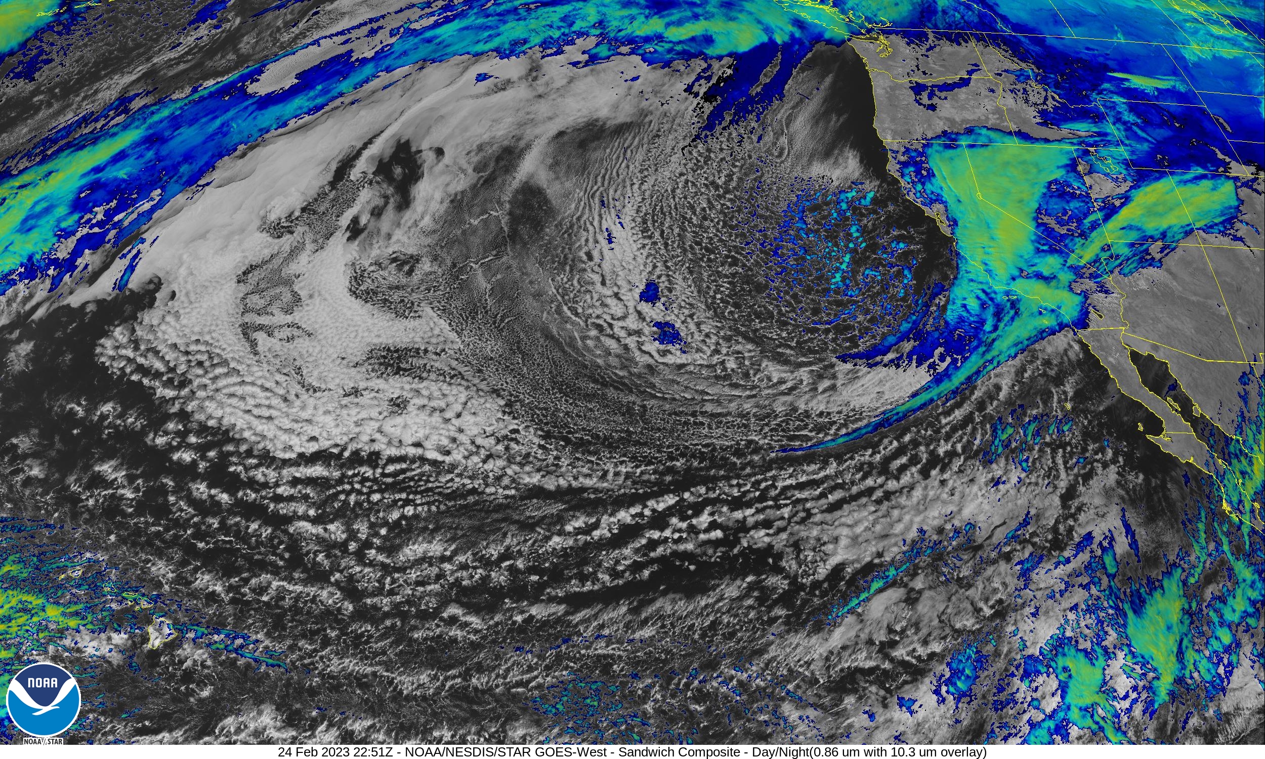
Still a couple of days away the next storm is supposed to bring 0.5 to 1.0 inches of rain here. Reminds me of a Kestrel poised to strike.

Detailed Forecast​

Tonight
Mostly clear, with a low around 50. Calm wind.
Sunday
Sunny, with a high near 79. Calm wind becoming west around 5 mph in the afternoon.
Sunday Night
Mostly clear, with a low around 54. Calm wind.
Monday
Mostly sunny, with a high near 78. Light west wind becoming southwest 5 to 10 mph in the afternoon.
Monday Night
Partly cloudy, with a low around 46. Northeast wind around 5 mph becoming calm.
Tuesday
A slight chance of rain after 4pm. Sunny, with a high near 68. Chance of precipitation is 10%.
Tuesday Night
A chance of rain, mainly after 10pm. Mostly cloudy, with a low around 46. Chance of precipitation is 40%.
Wednesday
A chance of rain. Partly sunny, with a high near 64.
Wednesday Night
A chance of rain. Mostly cloudy, with a low around 46.
Thursday
A chance of rain, mainly before 10am. Partly sunny, with a high near 66.
Thursday Night
A chance of rain. Mostly cloudy, with a low around 46.
Friday
A slight chance of rain. Partly sunny, with a high near 65.
Friday Night
Partly cloudy, with a low around 42.
Saturday
Mostly sunny, with a high near 65.
 
Light rain here since Friday. Not heavy, but it hasn't stopped. About 2" so far. Heavier rain is forecast for Monday night, then rain or a chance of rain every day next week.
 
Another 0.5" last night and now it's starting to get heavier. Rain just sort of materializes on the radar over my area.
 
no rain for us in any of this, we got some birdpiss not-even-mist one day out of all that stuff last week. now its; just getting "hot" here--was about 88F here today for a high, and when i got home towards 6pm it was still over 80f.
 
Since Sunday, just under 8" of rain. The ground is definitely saturated.

The latest drought map shows a lot of places are kind of dry, especially west Texas.
1738740629790.png
 
From
SF Gate article

Atmospheric river storm breaks San Francisco rain record set in 1887​

The North Bay absorbed the most powerful impacts from the recent atmospheric river. In Sonoma and Marin counties, gusty winds and heavy rainfall prompted several road closures and landslides.

In Forestville, a house slid into the Russian River, which has reached flood stage as of Wednesday morning. Flood warnings issued for areas of Napa County remain in effect even as the rain dies down because of runoff that is raising water levels in the Napa River. The North Bay also had some of the highest rainfall totals; Mount Tamalpais in Marin County has recorded 17.44 inches since Friday.

Downtown San Francisco was drier, but it still had a big day. The area recorded 2.53 inches on Tuesday, its highest daily rain total since 1887 when 2.22 inches fell.

I guess I got off lucky with only 8 inches. Mount Tamalpais is just a few miles from here.
Years ago, I remember the record rain here when we got 8 inches in a few hours. Lots of flooded roads and houses.
 
We'd be lucky to get 8" all year...maybe even in 2 years. ;)
 
Here’s the next low pressure system from wich we hope to get some rain from the tail end of. Followed by two more north of Hawaii coming next week.
 
La Niña Rain Gage
Nothin'/Skunked-Foggy Doggy-Play Misty-Drizzle Corn-Light Showers-Steady Soaker-Bands/Sheets-Cats & Dogs
***********************************************************************:)
Not showing up as measurable yet but radar seeing more coming in.
 
Last edited:
Another 1.6" overnight. Season total is around 26", which is just about where it was this time last year.
All 7 reservoirs in the local water district are reporting 100% capacity, so we'll be good even if it doesn't rain anymore for the season.
 
We got a whole 1 inch in the last day from the "atmospheric river". 🫤

Oh well, around here we don't have much by the way of rivers anyway. We do have creeks though. Although I do here Trump had the great big Delta faucet opened. Or is that a Kohler? Moen? I-don't-know, cuz those press guys never ask the obvious questions.

Anyway it looks like I got a week or so to do some weeding done before the next sprinkle next week.
 
Last edited:
This is what our atmospheric rivers look like:
View attachment 365389
Humm, from here it doesn't look like enough to fill the creek. Perhaps if someone in your states asks nicely Mr. President will have the army turn on the big Delta faucet in your area.
 
Last edited:
Satellite view of the next storm. Still not looking all that great but supposed to eclipse the last one by quite a bit.
 
suposeldly we'll get some rain thsi week...but last time they said this it didn'thappen.

Tonight
Clear. Lows 44 to 52. Southwest wind 5 to 10 mph in the evening becoming southeast around 5 mph after midnight.
Tuesday
Partly sunny and cooler. Highs 65 to 70. Southeast wind 10 to 15 mph in the morning becoming southwest 10 to 20 mph in the afternoon.
Tuesday Night
Clear in the evening then becoming partly cloudy. Colder. Lows 37 to 47. Southwest wind 10 to 20 mph in the evening becoming south 5 to 10 mph after midnight.
Wednesday
Partly cloudy. A slight chance of showers in the morning, then a chance of showers in the afternoon. Cooler. Highs 59 to 64. Southeast wind 5 to 10 mph in the morning becoming southwest in the afternoon. Chance of rain 20 percent.
Wednesday Night
Considerable cloudiness in the evening then becoming partly cloudy. A chance of showers. Lows 42 to 49. Northwest wind 5 to 10 mph in the evening becoming east around 5 mph after midnight. Chance of rain 30 percent.
Thursday
Considerable cloudiness with a 30 percent chance of showers. Warmer. Highs 64 to 71.
Thursday Night
Cloudy. A chance of showers in the evening, then showers likely after midnight. Not as cool. Lows 48 to 55. Chance of rain 60 percent. Rainfall less than a quarter of an inch.
Friday
Showers. Highs 65 to 72. Chance of rain 80 percent. Rainfall up to a half of an inch possible.
Friday Night
Considerable cloudiness. Showers likely in the evening, then a slight chance of showers after midnight. Colder. Lows 41 to 48. Chance of rain 60 percent. Rainfall less than a tenth of an inch.
 
Rain is coming....
Those amounts shouldn't cause too much flooding. Phoenix might get 0.1".
I'm looking at another 2" or so here by Friday.

1739324920271.png
 
Well we got .06 inches in the last 24 hours..... Which is from the .06 inches of rain we got in the last 3 hours. All of it welcome as my friend that still has a standing house in the Palisades tells me it is keeping the toxic dust down and gives him some rest from wearing a n95 mask all the time. 😬
 
Back
Top