A few photos from the trail.

dogman dan

1 PW
Joined
May 17, 2008
Messages
36,380
Location
Las Cruces New Mexico USA
I've been enjoying this trail lately, now that I have a 5304 that won't melt on me. I still ride early in the morning, on these 100 F days. The trail goes through desert for a few miles, and then follows the edge of a mountain for lots of fun stuff with steep grades, sharp rocks, and maybe a plunge into cactus if you lose steering popping a wheelie up the steep parts. The trail is in the Dona Anna mts, in Dona Anna county New Mexico. The full loop is about 10 miles, and climbs a thousand feet or so, not counting all the ups and downs that increase the total vertical on the route. Today I rode about 8 1/2 miles of it, passing on the severely technical upper loop that really does require a good full suspension bike.

This is a veiw back the trail to the car, about halfway to the mountain. The car is parked at the base of Goat Hill, with the radio towers. 1.5 miles up the trail, looking back.jpg

Looking from the base of the Dona Anna mountains towards The Organ mts and my house in the neighborhoods along the highway.Towards my house.jpg

Now looking more southwest, towards central Las Cruces. Towards town.jpg

Looking back east again, the trails are single track, but do intersect some 4x4 roads along the way. The rock climbing in the organ mountains is so hard that it has never attracted climbers worldwide. The hike to the climb allways exhausted meLooking east, towards the Organ mts..jpg

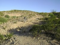
From the same spot as the previous shots, towards the fun stuff on the mountain. Looking straight north. The Dona Anna mts are old extinct volcanos, eroded down to the granite cores.Towards the fun stuff.jpg

This is further up the trail, now on the upper section, that has several loops that allow some technical riding while still able to bail out if it gets too hard. The lower trail is graded pretty nice, uphill but not too steep. The upper loops are game on, with lots of gully dips that are at least 25 degrees up the opposite side, and the rest of it pretty steep, like 7-12 %. The gully dips also usually feature some razor sharp rocks at the bottom to shred tires on.View attachment 4

From about the same area, at one of the loop intersections. Looking back to the car at Goat Hill.Trail intersection 1.jpg

And the same spot, looking up the mountainTrail intersection 2.jpg

One of the more technical spots, a rock chute thats damn steep. Coming down this is where I blew my tire a few weeks ago and got to walk back to the car.View attachment 1

Go down this trail, and you get into some very very, VERY technical riding. I usually skip it since I don't have a DH bike. Turning off to the lower section of the loop here, I have 4.5 miles of trail, about half of which can be ridden very fast. The top part needs to go slower, with all the razor rocks and such in the bottom of each dip.A good place to turn around.jpg

I took no good pictures on the downhill loop of the trail. The return loop is less technical except for a few spots, lower on the mountainside, and is good for faster riding . Once the trail leaves the mountain you get 3 miles of zooming down nice trails to the car. The last three miles of 3 or 4% downhill grade can be ridden as fast as you are brave enough for.
 
Very nice terrain Dogman. Thanks for the pics.
Looks very close to the Mojave Desert that we have here in California (except maybe for the Joshua Trees).
Nice that you're ebike is setup to go offroad too. Looks like fun.
 
Nice pics. I'm jealous :cry: I'd love to see some video. The last fast 3 mi. would be really cool 8) I got mine tore apart. I've got a pedal stuck so bad I'm going to change the crank I think. It's just an old 1 piece steel crank. I'd love to get an offroad ride going too. Love to see the ride reports with such nice pics.
 
Specifically its Chihuahuan desert biome. Elevation 4000-5000 feet. A bit different than Mohave that is lower in elevation I think. The main thing is the hard freezes we get in the winter, sometimes as low as 10F, and 18F every year for sure. So we can't grow some things common in Tuscon unless they are planted on the south side of a house that leaks heat all night. Most of what you see is non native, lots of mesquite and creosote bush that were both brought from Mexico one cow pie at a time on the road to Santa Fe. The native stuff is yucca, ocotillo, barrel cactus, desert willow, and prickly pear. No joshua trees, no paloverde. The freezes limit the growth of the mesquites so they never get Tuscon size. Every ride you see lots of rabbits, hawks, lizards, and hopefully not, snakes. The Dona Annas seem to have more rattlesnakes than anywhere in the area. Once in a while you get to see a herd of mule deer, and hopefully not, the mountain lions that eat em. The great thing about this trail is it's all rocky or gravely. Just about everywhere else here is too steep, or buried in bottomless sand. there are other trails in the valley, but they are both way to rocky and technical for anything but DH bikes with huge suspension travel.

The bike is just for dirt riding, though it does ride nice in the street. The other two bikes do steet better with different tires. I run the fattest thing that'll fit on the dirt bike. I'd love a surly with 3" tires for the sandy stuff.

I could shoot video with this camera, but I doubt it would come out that good. Its ok for the kid blowing out the birthday candles, but anything in real motion is just a blur with this cheap camera. Need to get a hig def video camera someday, but I'd rather keep buying bikes and batteries.
 
Simply beautiful, dogman! Enjoy.
otherDoc
 
The two deserts look pretty similar. Mojave Desert is mostly high desert plain about the same elevation 4000 - 5000ft above sea level and lots of low rolling mountains. Typically gets cold down to 20 degrees Farenheit in the fall & winter months and up to 120 degrees in spring & summer months. Here's some pictures I took 3 years ago when I used to go hunting with some friends of mine. Last pic is a winter shot and you can see the snow in the distance mountains which are just slightly higher.
DSCN4593.jpg

DSCN4623.jpg

mavs_revo_and_talon.jpg

Snow_on_the_mountains_031206.jpg
 
Man I dont know if i should pitch a tent looking at the photos or fly out there and do it for real. Absolutely amazing. Man! Kudos to you!
 
I guess I've never seen real Mojave desert, Just the stuff on the 8 or the 10 going to LA that is lower elevation. This would be further north then? I was thinking of the stuff with the joshua trees everywhere and mesquites that are real trees, where here they are stunted by the winter. Now that I think more, that's Sonoran desert I think.

That does look a lot like home in the pic. Winter is the time to enjoy it, right now it's like , suns up time to head home. In the winter, midafternoon is perfect and the temp allows the dogs to come along.


The really nice thing about this particular trail is that it was built by mt bikers for mt bikes. So the grades are perfect on 80% of it to ride without a motor even if you aren't real strong. Yesterday I drained 7 ah out of my 8 ah pack but pedaling only, I doubt I'd have ridden half as far. I rode about 8 1/2 miles and never had to get to the red zone, but using the motor mostly as a mere assist I have noticeably sore legs this morning. There are zillions of miles of road out here, but 99% of it is hell on a bicycle, with miles of deep sand, or grades above 15%. Nice on a motorcycle though, I used to ride the hell out of it all on a trials bike I had 25 years ago.
 
dogman said:
I guess I've never seen real Mojave desert, Just the stuff on the 8 or the 10 going to LA that is lower elevation. This would be further north then? I was thinking of the stuff with the joshua trees everywhere and mesquites that are real trees, where here they are stunted by the winter. Now that I think more, that's Sonoran desert I think.

I stayed in the south Mojave once (just north of I-40) and it was rather different from the pictures above. Had a sprinkling Joshua trees. Not really any big mesquite though. Really beautiful though. Best star gazing I've ever experienced. Would love to go back w/ an ebike.

I'm really excited for having an ebike when I move out to Portland. Should be quite the up grade from Omaha, Nebraska for recreational/exploring rides.
 
Sacman said:
The two deserts look pretty similar. Mojave Desert is mostly high desert plain about the same elevation 4000 - 5000ft above sea level and lots of low rolling mountains. Typically gets cold down to 20 degrees Farenheit in the fall & winter months and up to 120 degrees in spring & summer months. Here's some pictures I took 3 years ago when I used to go hunting with some friends of mine. Last pic is a winter shot and you can see the snow in the distance mountains which are just slightly higher.

mavs_revo_and_talon.jpg


E-bikes and airguns for you also I see. I am still working on both of these after a year or better but expect I will finish them shortly.
Thought about purchasing an Air Force but decided to make my own since I already had a an Outlaw in .25. I actually built the bike to take me to the mountains to shoot. Hope it will do that looks like lots of BMC's overheat when climbing.


Giant600sm.jpg


newredgun1.jpg
 
Looks like some very nice country to be riding in and you have the bike to do it. It is near 100 deg around here as of late and I don't like it. Only a few days a year like this though unlike your area. Thanks for the pics and post.
 
Dogman,

That is incredibly beautiful land. You can only get so much variation here in new England. Yes mountains, yes ocean, but no ridable vertical elevation gains of more than about 2,000 feet tops. Also no wide open areas with 50+ mile visibility. On the best days here you're lucky to get 40 mile visibility. All the really big mountain summit roads are posted no bicycles now as are the majority of open area parks near Boston.

Bill
 
It was a nice day, visibility wise. 200 miles is not unheard of, but typical is 100 miles. One memorable day I saw colorado peaks from southern new mexico. New Mexico is a great place to live, as long as you bring your own money. We encourage it, there is no industry in Las Cruces whatsoever. So comon out, spend some money, and maybe we can latch on to some of it. :lol: A little more global warming and we'll have some ocean too. :lol:

As much as I love the desert, a tree or two is nice too, and just a short drive away. Yesterday I took a spin up to pine trees in the car. Home is 4500 feet, and the picnic was at 7500. Going the other direction, I could have driven to 9000 feet at the base of the ski area. You really can just drive to the climate of your choice. Can only afford to live in the desert though.

Saw bambi along the way.
 
i agree with fifthmass im from worcester and dont get the pleasure of nice open roads and views like that.

if i took pictures you would probly see more car exhaust than anything.
 
Unfortunately , at least close to town, we get some pretty smoggy days now. It's not that bad, but when you grew up with this anything less than 50 mile visibility seems horrible. Low humidity is a big part of the clear air. But in the winter, on a day with no wind, and more humidity, the town will smog up fast.
 
Today I went out to the single tracks, and hunted down something I spotted on google earth. Sure enough, there is a "secret trail" out there, not marked with blm markers and craftily hidden where none of the trails are visible from the adjacent roads or Mountain bike trails. Very sneaky dudes...

Anyway, its a short but sweet section of trail with steep drops, and a few ladder bridges. Lame bridges by Pacific northwest standards, but for a guy crossing one for the first time, a bit freaky.gully1.jpg

This gully is the upper exit from the trail, connecting to a nice, seldom used ridgetop road. Perfect for taking the dogs along, since I won't run into everybody on this road. Another shot of the gully, little half pipe turns.gully 2.jpg

Then a nice drop to the first ladder.first ladder.jpg

The ladder closer.first ladder close.jpg

And a shot of the second ladder, three and four are in the shot if you want to play wheres waldo.View attachment 1

. Ladder 3 is only about 4 feet long, and didn't rate a photo. Here is ladder 4.2nd ladder close.jpg
 
Here's looking back at the 4th one. Notice the nice 2 foot drop just before you hit the boards. 4th ladder look back.jpg

From a gully on the trail, looking at the badlands they built this little playground in.badlands.jpg

From a hilltop, looking the other way back towards the badlands.look back at the badlands.jpg

One last roller coaster drop back towards the parking lot a half mile away.roller coaster exit to parking lot.jpg

And lastly, a horny toad I caught a pic of the other day.horny toad.jpg
 
More photos of the trails in the Dona Anna mts. I'm really enjoying my dirtbike on these trails. Today I took another trail I hadn't ridden entirely yet, and this time rode it in the right direction. This one is called rollercoaster, and is definitely funner going down it! :D It starts out at the bottom of the Dona Anna mts, gets techical for about a half mile, then it gets very smooth and goes down huge whoop de doos. The gullies get washed out at the bottoms, so some have to be taken slow, but others , you can zoom em.

This is some of the steep rocks at the top, and looking various directions from there.View attachment 8Start of Roller coaster  trail 2.jpg[attachment=6]White face.jpg[/attachment

Then some shots going down the coaster to the little peaks known localy as dick rock. An amazing resembance, the rock is the one pointed out. The trails at Dick rock are very technical, built just for MTB racing. Fortunately the alternate easy routes are easy enough so I can at least walk the bike up the easy parts. The hard parts are freaking rock climbs.
 

Attachments

  • White face.jpg
    White face.jpg
    53.6 KB · Views: 966
  • Down the coaster 1.jpg
    Down the coaster 1.jpg
    56 KB · Views: 966
  • Down the coaster 2.jpg
    Down the coaster 2.jpg
    92.6 KB · Views: 966
  • Down the coaster 3.jpg
    Down the coaster 3.jpg
    83.9 KB · Views: 966
  • Steep stuff 1.jpg
    Steep stuff 1.jpg
    115.5 KB · Views: 966
  • steep stuff 2.jpg
    steep stuff 2.jpg
    77.5 KB · Views: 966
  • Dick rock..jpg
    Dick rock..jpg
    100 KB · Views: 966
Back
Top