liveforphysics said:
Enjoy the incredible adventures my friend!
Thanks Luke! That we have been and will continue for the next 4 weeks, and will hopefully serve as encouragement for you're antarctic solar powered trip.
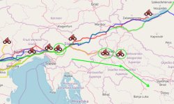
We're about 65km out of Zagreb in Croatia now, cloudy weather, stopped for a brief rest on the side of the road and then a local coffee shop owner came out to offer us a table, free drinks, snackfood, and unlimited wifi.

So here I am.
Anyways for those curious about strategy, outside of riding as many hours as possible from 7am - 9pm, there's sooo many minor optimizations that are always on the back of one's mind.
Morning / Evening vs Noon Sun
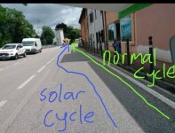
When there are trees or building around, you can spend large amounts of time riding through shadows during the time when the sun lower on the horizon, while in the couple hours around Noon the sun is mostly directly overhead. So it makes full sense to be riding all the time around noon when the sun is above since you'll get the same solar input when moving or stopped. But in the evenings and mornings, you can get 3-4 times more average solar energy if you stop and point the panels right at the sun, compared to riding when they'll frequently be shaded or not optimally aligned. It's best to keep riding regardless, but if you ARE going to stop and do a solar recharge, it's best to time that for lower sun elevation and keep rolling when the sun is straight above.
East/West and North/South
This trip is mostly going eastwards, with the sun going east to west. So we only get to take advantage of the panel tilting when we are travelling in a northern or southern direction. The difference that this makes can be huge; when we were in Slovenia the other day we were still getting 350-400 watts in the evening when the road was either NE or SE, but when it was straight east, we'd only have about 200 watts. So if you have an option in the route plan, you'd want to do roads that contain a northern/southern travel direction in mornings or evenings, with the straight eastern roads around noon, if otherwise the distances are the same.
Actual route planning
Actually having a route plan with live maps and is a necessity to avoid all kinds of inefficient roads and navigation choices. This was the topic of great discussion amongst the various participants during the first days riding through france, and every imaginable navigation app seemed in play. As mentioned Google cycle routing is terrible for sending you down almost non-existant pathways. What would be most ideal is a route planner that selects the large roadways and highways that you're legally allowed to bike on, rather than the more scenic or low-traffic paths that are on most cycle touring suggestions.
We settled with Komoot after trying a few options.
https://www.komoot.com/
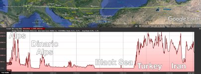
Anne-Sophie prepares trips in advance which we load on both our phones and a tablet, downloaded for offline viewing as well, and then during the ride we're frequently evaluating and sometimes changing this in response to road conditions as we roll. Usually the person in the front has the map in a high level of zoom to see all the imminent details with roundabouts, intersections etc., while the person rowing has the map zoomed much further out to look at the big picture. That's where we decide to override the suggested route if there's a more major roadway that still allows bicycles, it influences us whether it's worth tilting the solar roof for better sun exposure based on the average direction for the next many km or not, and it also lets us see the big picture elevation profile so that we can budget the battery accordingly.
Tandem setups have a big advantage here, I imagine if I was riding solo that I'd be very frequently stopping to double check route decisions and loosing some time that way, but in a tandem with a copilot there's no need to stop for this.

