Kingfish
100 MW
Backfill #11 – Part 2: Thursday, August 18th
Eureka to Gold Beach, Oregon
Lunch
Consulting the Google Maps oracle, there’s a Subway up ahead; sounds good to me. When I stepped inside I nearly fell over from the warmth and heat. Ordered up a sandwich and milk; that chocolate chip cookie looks good too. Time for a quick post on ES to let Rassy know where I am. Fed and rested, the sun has graced us with its’ presence, warming up the afternoon. Lovely!")
Heading out, the Redwood Highway jumps from US 101 over to US 199 northeast towards Grants Pass, but we forge on ahead on this big wide well-maintained bit of road with large margins northward. There’s a covered bus stop on the side of the road, and I espy the dark-haired girl with sunglasses; as I pass I point to her as if to say “It’s You! Look how far we’ve come!!” She flashes me a big wide smile and waves back! Kindred friends on the road.
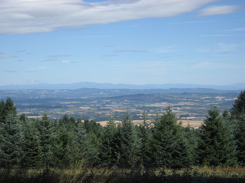
Nearly straight ahead over a gentle rise and then down again to cross over the Smith River, the scenery is of vast tracts of inland farmsteads bordered by lazy forested hills. Beautiful weather for a ride with only a slight breeze. The path towards back towards the sea and then north, parallel to the coast, then just past Pelican State Beach after a small rise I cross into Oregon Country at 3 PM. It wasn’t very picture-worthy, though I stopped post it on ES, resting for just a moment to water-up. It’s warm! The road becomes aptly named as the Oregon Coast Highway, and travels along an elevated plain that is mostly straight with wide margins and well maintained. Farmers use this road too; there was more than one rig going down the road here, slowing up traffic.

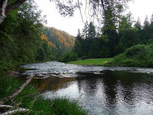
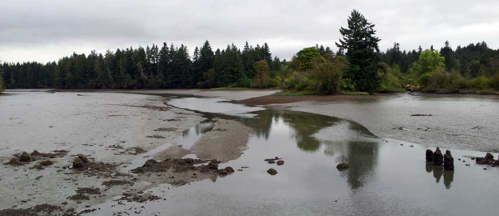
Borrowed image of the Smith River, seen from the Hiouchi Trail
Entering Brookings was a little treacherous and frustrating with local drivers not minding themselves. One smoggy turd in an old sporty car with a blown muffler and likely blown subwoofer, on his cellphone, couldn’t have the decency to do the speed limit, was too busy to see me, and made a right turn without signally. :x This was right after another idiot in a small light white truck passes me with centimeters to spare; I don’t get it: Am I taking up too much room? I don’t want to stop; shake it off and keep going.
The road returns to rural with gentle grades, being most pleasant and scenic with sea stacks dotting the coast. I am optimistic because there is a short distance to go and the pack is solid on the reserve, holding well in the 56-volt range. With about 30 miles to go, I could open up the throttle and make some great time on these straightaways! Pretty soon though the hills begin to steepen and the winds pick up; I’m hot and ready for a good break so I pull off at Whalehead Road leading to the Beach Resort with 18 miles to go and making good time.
The Wind
It’s a long climb up into Samuel H. Boardman State Park with some crosswind, but the bike climbs well. Down the backside, some headwind – but nothing serious. Climb and descend, pass close to the shoreline for incredible sea stack views and crystal-clear coves; gosh if there’s was an easy way to pull off and snap a photie I’d have done it, but the road is busy. The last hill following Mack Arch Cove though it begins to really get windy and I have to drop gears to climb it. As I crest, I am met head-on with serious buffeting and have to throttle to get down the hill. The buffeting is absolutely horrible as I reach the flats. :x The cyclists going south are struggling to maintain balance. I am at WOT and barely doing 12 mph. Had my rig not have so much mass, I would have been blown over; for once I was grateful to be heavy. The worst was yet to come: Crossing the Pistol River Bridge was the dangerous wind experience I have ever had, and I am absolutely thankful no cars tried to pass me cos it was everything I could do to keep the bike pointed forward and stay away from the guard railing. If I had to guess – the wind exceeded 35 mph with gusts on top of that. Once on the other side of the bridge, the bluff to my immediate right deflected some of force. I stopped at the first pullout to rest where the Pistol River Loop connects. This was a nightmare! Caught my breath and continued on for another mile, pulling off at Meyers Creek Road to rest. Maybe it will let up after Meyers Cove. Driving up the slope and away from the shore through Cape Sebastian State Park, the buffeting reduced, though I still had a terrible headwind.

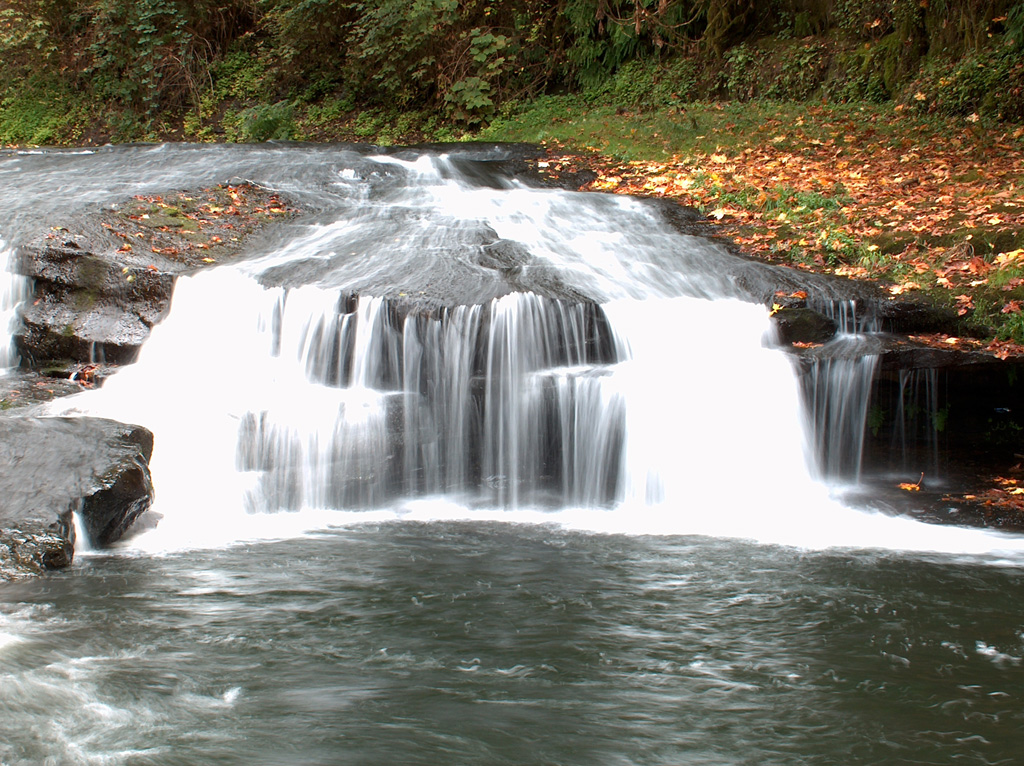
Borrowed image of Samuel H. Boardman State Scenic Corridor and Cape Sebastian, South Oregon Coast - looking south.
Crossing Hunter’s Creek, I stopped at the wye and checked the map; damned dumbphone can’t zero in on my position and I’m left to guess if I’ve made it or not. Studying the maps, I haven’t seen an airport, so it must be ahead. At last there is development on both sides of the road; this is it – Gold Beach. The highway rides a bit high on the side of a rise and I can see a good ways off to the left. I am now parallel with the airport, so out of a lark, I take an opportunistic left when the traffic is clear and head on down to Airport Way and take a right, then a left on Oceanside Drive (that’s the one I need to find), go to the end and it wraps around; there’s the RV park of the same name. OK, gravel entrance <deep breath>, go slow… I see the numbers, head towards the end… and I hear Rassy call me out!

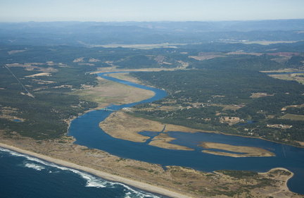
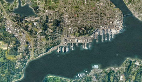
Borrowed image of Gold Beach, Oregon. The RV park is on the south corner where the Rogue River exists to the sea.
Gold Beach
It’s 4:30 PM. In the last 8 miles I had lost 2 volts off the pack fighting the wind, which was – impossible! I don’t know how I could have made the original goal of Port Orford which is another 25 miles away. I’ll have to rethink my plans going forward in a most serious way.
Rassy is a perfect host, and I am welcomed into his camp with his long-time friends! Eating outside though was a complete chore; it reminded me of being on a Destroyer in rough sea and trying to eat with one arm wrapped around the plate, holding your drink, and the other arm trying to feed your face between the surges and swells and chop. :lol: The plates would blow away, the beer would get knocked over, and the food was at risk as well. <sigh> Still – it was great to be welcomed.
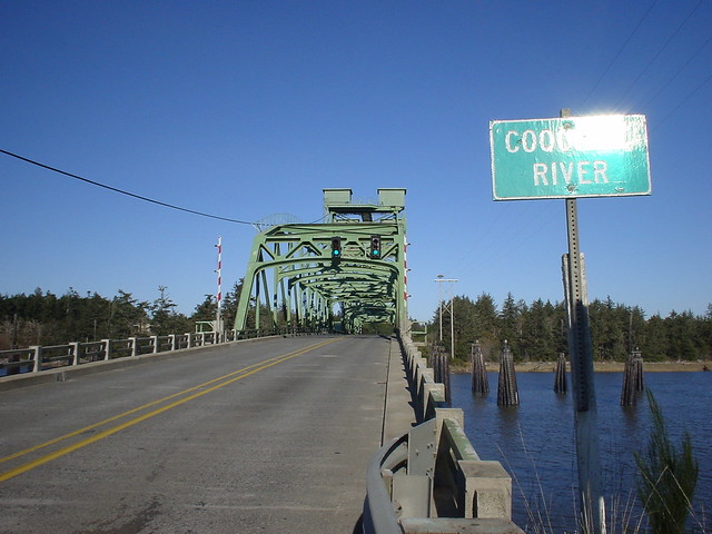
Charging was easy enough; just plug right into the power post. Rassy thought it would be wise to cover the bike/charger with a tarp to redcue the risk of dewy moisture in the morning – so we did that and covered the bike. The wind blew the tarp all night. I took some really neat shots of the recently renovated bridge over the Rogue River from a couple of different perspectives. I also took a panorama of Gold Beach at sunset when the orangey rays were hitting the windows of the city, and again after sunset – with just the city lights. All these photos though are gone.
The original plan for Rassy I think was to take me out on the boat and go fishing. Unfortunately the wind was so fierce that their attempts earlier in the day were aborted after about an hour. If the wind didn’t let up then the trip was a bust. Rassy has one of those camping vans and I was set up nicely and most cozy. Inside with his laptop over wireless, he consulted NOAA and it appeared the worst of the wind was here already though would last another day. Weekend traffic would start tomorrow. I decided to find a way out and back inland to get away from it. Instead of heading to Lincoln City or Newport, the route to Florence would be a better choice with Reedsport and a fallback if conditions get mighty worse. From there, Rassy picked out a path north to McMinnville that sounded quite reasonable. Glad to have his friendship and experience! :wink:
We called it an early one for an equally early morning rise.
Stats:
Start V = 63.4; End V = 54.3
Distance = 140.4; Total Odometer = 1985 miles
Regen = 1.0%; Vmin – 52.7
MaxS – 41.2; AveS = 28.1
Trip Time = 4:59:57
Will I make it to Florence? Stay tuned… KF
PS: How am I doing? Too long-winded? This was the only day without any recoverable images.
Eureka to Gold Beach, Oregon
Lunch
Consulting the Google Maps oracle, there’s a Subway up ahead; sounds good to me. When I stepped inside I nearly fell over from the warmth and heat. Ordered up a sandwich and milk; that chocolate chip cookie looks good too. Time for a quick post on ES to let Rassy know where I am. Fed and rested, the sun has graced us with its’ presence, warming up the afternoon. Lovely!
Heading out, the Redwood Highway jumps from US 101 over to US 199 northeast towards Grants Pass, but we forge on ahead on this big wide well-maintained bit of road with large margins northward. There’s a covered bus stop on the side of the road, and I espy the dark-haired girl with sunglasses; as I pass I point to her as if to say “It’s You! Look how far we’ve come!!”
She flashes me a big wide smile and waves back! Kindred friends on the road. Nearly straight ahead over a gentle rise and then down again to cross over the Smith River, the scenery is of vast tracts of inland farmsteads bordered by lazy forested hills. Beautiful weather for a ride with only a slight breeze. The path towards back towards the sea and then north, parallel to the coast, then just past Pelican State Beach after a small rise I cross into Oregon Country at 3 PM. It wasn’t very picture-worthy, though I stopped post it on ES, resting for just a moment to water-up. It’s warm! The road becomes aptly named as the Oregon Coast Highway, and travels along an elevated plain that is mostly straight with wide margins and well maintained. Farmers use this road too; there was more than one rig going down the road here, slowing up traffic.
Borrowed image of the Smith River, seen from the Hiouchi Trail
Entering Brookings was a little treacherous and frustrating with local drivers not minding themselves. One smoggy turd in an old sporty car with a blown muffler and likely blown subwoofer, on his cellphone, couldn’t have the decency to do the speed limit, was too busy to see me, and made a right turn without signally. :x This was right after another idiot in a small light white truck passes me with centimeters to spare; I don’t get it: Am I taking up too much room?
I don’t want to stop; shake it off and keep going. The road returns to rural with gentle grades, being most pleasant and scenic with sea stacks dotting the coast. I am optimistic because there is a short distance to go and the pack is solid on the reserve, holding well in the 56-volt range. With about 30 miles to go, I could open up the throttle and make some great time on these straightaways! Pretty soon though the hills begin to steepen and the winds pick up; I’m hot and ready for a good break so I pull off at Whalehead Road leading to the Beach Resort with 18 miles to go and making good time.
The Wind
It’s a long climb up into Samuel H. Boardman State Park with some crosswind, but the bike climbs well. Down the backside, some headwind – but nothing serious. Climb and descend, pass close to the shoreline for incredible sea stack views and crystal-clear coves; gosh if there’s was an easy way to pull off and snap a photie I’d have done it, but the road is busy. The last hill following Mack Arch Cove though it begins to really get windy and I have to drop gears to climb it. As I crest, I am met head-on with serious buffeting and have to throttle to get down the hill. The buffeting is absolutely horrible as I reach the flats. :x The cyclists going south are struggling to maintain balance. I am at WOT and barely doing 12 mph. Had my rig not have so much mass, I would have been blown over; for once I was grateful to be heavy. The worst was yet to come: Crossing the Pistol River Bridge was the dangerous wind experience I have ever had, and I am absolutely thankful no cars tried to pass me cos it was everything I could do to keep the bike pointed forward and stay away from the guard railing. If I had to guess – the wind exceeded 35 mph with gusts on top of that. Once on the other side of the bridge, the bluff to my immediate right deflected some of force. I stopped at the first pullout to rest where the Pistol River Loop connects. This was a nightmare!
Caught my breath and continued on for another mile, pulling off at Meyers Creek Road to rest. Maybe it will let up after Meyers Cove. Driving up the slope and away from the shore through Cape Sebastian State Park, the buffeting reduced, though I still had a terrible headwind.
Borrowed image of Samuel H. Boardman State Scenic Corridor and Cape Sebastian, South Oregon Coast - looking south.
Crossing Hunter’s Creek, I stopped at the wye and checked the map; damned dumbphone can’t zero in on my position and I’m left to guess if I’ve made it or not. Studying the maps, I haven’t seen an airport, so it must be ahead. At last there is development on both sides of the road; this is it – Gold Beach. The highway rides a bit high on the side of a rise and I can see a good ways off to the left. I am now parallel with the airport, so out of a lark, I take an opportunistic left when the traffic is clear and head on down to Airport Way and take a right, then a left on Oceanside Drive (that’s the one I need to find), go to the end and it wraps around; there’s the RV park of the same name. OK, gravel entrance <deep breath>, go slow… I see the numbers, head towards the end… and I hear Rassy call me out!
Borrowed image of Gold Beach, Oregon. The RV park is on the south corner where the Rogue River exists to the sea.
Gold Beach
It’s 4:30 PM. In the last 8 miles I had lost 2 volts off the pack fighting the wind, which was – impossible!
I don’t know how I could have made the original goal of Port Orford which is another 25 miles away. I’ll have to rethink my plans going forward in a most serious way. Rassy is a perfect host, and I am welcomed into his camp with his long-time friends! Eating outside though was a complete chore; it reminded me of being on a Destroyer in rough sea and trying to eat with one arm wrapped around the plate, holding your drink, and the other arm trying to feed your face between the surges and swells and chop. :lol: The plates would blow away, the beer would get knocked over, and the food was at risk as well. <sigh> Still – it was great to be welcomed.
Charging was easy enough; just plug right into the power post. Rassy thought it would be wise to cover the bike/charger with a tarp to redcue the risk of dewy moisture in the morning – so we did that and covered the bike. The wind blew the tarp all night. I took some really neat shots of the recently renovated bridge over the Rogue River from a couple of different perspectives. I also took a panorama of Gold Beach at sunset when the orangey rays were hitting the windows of the city, and again after sunset – with just the city lights. All these photos though are gone.
The original plan for Rassy I think was to take me out on the boat and go fishing. Unfortunately the wind was so fierce that their attempts earlier in the day were aborted after about an hour. If the wind didn’t let up then the trip was a bust. Rassy has one of those camping vans and I was set up nicely and most cozy. Inside with his laptop over wireless, he consulted NOAA and it appeared the worst of the wind was here already though would last another day. Weekend traffic would start tomorrow. I decided to find a way out and back inland to get away from it. Instead of heading to Lincoln City or Newport, the route to Florence would be a better choice with Reedsport and a fallback if conditions get mighty worse. From there, Rassy picked out a path north to McMinnville that sounded quite reasonable. Glad to have his friendship and experience! :wink:
We called it an early one for an equally early morning rise.
Stats:
Start V = 63.4; End V = 54.3
Distance = 140.4; Total Odometer = 1985 miles
Regen = 1.0%; Vmin – 52.7
MaxS – 41.2; AveS = 28.1
Trip Time = 4:59:57
Will I make it to Florence? Stay tuned… KF
PS: How am I doing? Too long-winded? This was the only day without any recoverable images.